
Gracias por apoyar a este sitio ❤️
Haz una donación
Haz una donación
Mapa topográfico Costilla
Haga clic en el mapa para ver la altitud.
Gracias por apoyar a este sitio ❤️
Haz una donación
Haz una donación
Acerca de este mapa
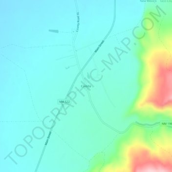
Nombre: Mapa topográfico Costilla, altitud, relieve.
Lugar: Costilla, Taos County, New Mexico, 87624, United States (36.95541 -105.55082 36.99541 -105.51082)
Altitud media: 2,398 m
Altitud mínima: 2,354 m
Altitud máxima: 2,574 m
Gracias por apoyar a este sitio ❤️
Haz una donación
Haz una donación
Otros mapas topográficos
Haga clic en un mapa para ver su topografía, su altitud y su relieve.
Taos Ski Valley
United States > New Mexico > Taos County
Taos Ski Valley is a village and alpine ski resort in the southwestern United States, located in Taos County, New Mexico. The population was 69 at the 2010 census. Until March 19, 2008, it was one of four ski resorts in America to prohibit snowboarding. The Kachina lift, constructed in 2014, serves one of the…
Altitud media: 3,307 m