
Haz una donación
Mapa topográfico Neuenbürg
Haga clic en el mapa para ver la altitud.
Haz una donación
Neuenbürg
The township (Stadt) of Neuenbürg covers 28.17 square kilometers (10.88 sq mi) of the Enz district, within the state of Baden-Württemberg and the Federal Republic of Germany. It is physically located on the Pfinzhügelland [de], on the southern reaches of the Kraichgau. The geological makeup of the municipal area is decided by the meeting of the Pfinzhügelland's muschelkalk and keuper and the Black Forest's buntsandstein plateaus. The main watercourse is the Enz, which flows in a deep bed of Middle Buntsandstein [de]. Where the Enz flows into Birkenfeld marks the lowest elevation above sea level in the municipal area, 309 meters (1,014 ft) Normalnull (NN). The highest is the top of the Heuberg, south of Dennach, at 709 meters (2,326 ft) NN.
Haz una donación
Acerca de este mapa
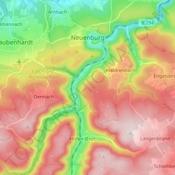
Nombre: Mapa topográfico Neuenbürg, altitud, relieve.
Altitud media: 518 m
Altitud mínima: 286 m
Altitud máxima: 727 m
Haz una donación
Otros mapas topográficos
Haga clic en un mapa para ver su topografía, su altitud y su relieve.