
Haz una donación
Mapa topográfico Bauschlott
Haga clic en el mapa para ver la altitud.
Haz una donación
Acerca de este mapa
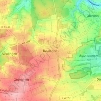
Nombre: Mapa topográfico Bauschlott, altitud, relieve.
Altitud media: 309 m
Altitud mínima: 239 m
Altitud máxima: 368 m
Haz una donación
Otros mapas topográficos
Haga clic en un mapa para ver su topografía, su altitud y su relieve.
Neuenbürg
Germany > Baden-Württemberg > Enzkreis
The township (Stadt) of Neuenbürg covers 28.17 square kilometers (10.88 sq mi) of the Enz district, within the state of Baden-Württemberg and the Federal Republic of Germany. It is physically located on the Pfinzhügelland [de], on the southern reaches of the Kraichgau. The geological makeup of the municipal…
Altitud media: 518 m
Haz una donación
Tiefenbronn
Germany > Baden-Württemberg > Enzkreis
The municipality (Gemeinde) of Tiefenbronn covers 14.79 square kilometers (5.71 sq mi) of the Enzkreis, a district of Baden-Württemberg, Germany. It is located on the edge of the Black Forest and the Upper Gäu [de]. The buntsandstein of the Röt Formation, under the Black Forest, extends into the municipal…
Altitud media: 448 m
Wimsheim
Germany > Baden-Württemberg > Enzkreis
The municipality (Gemeinde) of Wimsheim covers 8.06 square kilometers (3.11 sq mi) of the Enz district of Baden-Württemberg, a state of the Federal Republic of Germany. Wimsheim is located in the metropolitan areas of Pforzheim and Karlsruhe and on the edge of the Black Forest, the Neckar basin [de], and the…
Altitud media: 438 m
Haz una donación
Wiernsheim
Germany > Baden-Württemberg > Enzkreis
The municipality (Gemeinde) of Wiernsheim covers 24.62 kilometers (15.30 mi) of the Enzkreis, a district of the state of Baden-Württemberg and the Federal Republic of Germany. It is located in the metropolitan areas of Karlsruhe and Pforzheim, along the southwestern edge of the Neckar basin [de]. Wiernsheim…
Altitud media: 358 m
Illingen
Germany > Baden-Württemberg > Enzkreis
The municipality (Gemeinde) of Illingen is located at the eastern edge of the Enzkreis district, within the state of Baden-Württemberg and Federal Republic of Germany. It covers an area of 29.36 square kilometers (11.34 sq mi) that lies within the metropolitan areas of Karlsruhe and Pforzheim. Illingen is…
Altitud media: 279 m
Heimsheim
Germany > Baden-Württemberg > Enzkreis
The township (Stadt) Heimsheim covers an area of 14.3 square kilometers (5.5 sq mi) at the very southeastern tip of the Enz district. It is physically located in the foothills of the Black Forest, in the Heckengäu, a region geology is characterized by karstified and wooded muschelkalk hills. Because the…
Altitud media: 450 m
Haz una donación