
Haz una donación
Mapa topográfico Wiernsheim
Haga clic en el mapa para ver la altitud.
Haz una donación
Wiernsheim
The municipality (Gemeinde) of Wiernsheim covers 24.62 kilometers (15.30 mi) of the Enzkreis, a district of the state of Baden-Württemberg and the Federal Republic of Germany. It is located in the metropolitan areas of Karlsruhe and Pforzheim, along the southwestern edge of the Neckar basin [de]. Wiernsheim is physically in the Heckengäu, a region characterized by wooded and karstified hills of muschelkalk. Elevation above sea level in municipal area ranges from a low of 274 meters (899 ft) Normalnull (NN) on the Kreuzbach and a high of 464 meters (1,522 ft) NN in the southwest.
Haz una donación
Acerca de este mapa
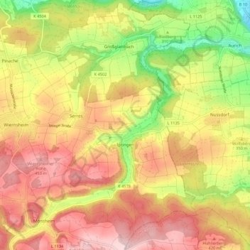
Nombre: Mapa topográfico Wiernsheim, altitud, relieve.
Altitud media: 358 m
Altitud mínima: 202 m
Altitud máxima: 482 m
Haz una donación
Otros mapas topográficos
Haga clic en un mapa para ver su topografía, su altitud y su relieve.