
Mapa topográfico Mount Hood
Mapa interactivo
Haga clic en el mapa para ver la altitud.
Acerca de este mapa
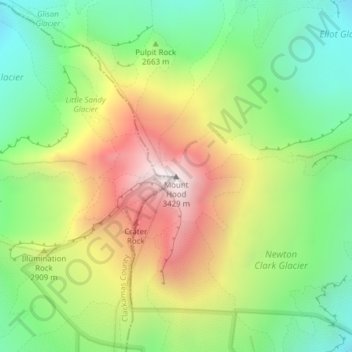
Nombre: Mapa topográfico Mount Hood, altitud, relieve.
Lugar: Mount Hood, Hood River County, Oregon, United States (45.37346 -121.69593 45.37356 -121.69583)
Altitud media: 2,716 m
Altitud mínima: 2,213 m
Altitud máxima: 3,416 m
Timberline Lodge is a National Historic Landmark located on the southern flank of Mount Hood just below Palmer Glacier, with an elevation of about 6,000 ft (1,800 m).
Otros mapas topográficos
Haga clic en un mapa para ver su topografía, su altitud y su relieve.
Hood River
United States > Oregon > Hood River County
Hood River, Hood River County, Oregon, United States
Altitud media: 112 m
Parkdale
United States > Oregon > Hood River County > Parkdale
Parkdale, Hood River County, Oregon, United States
Altitud media: 538 m
Odell
United States > Oregon > Hood River County
Odell, Hood River County, Oregon, United States
Altitud media: 244 m
Badger Lake Dam
United States > Oregon > Hood River County
Badger Lake Dam, Hood River County, Oregon, United States
Altitud media: 1,565 m
Government Cove
United States > Oregon > Hood River County > Cascade Locks
Government Cove, Cascade Locks, Hood River County, Oregon, United States
Altitud media: 89 m
Cascade Locks Marine Park
United States > Oregon > Hood River County > Cascade Locks
Cascade Locks Marine Park, Cascade Locks, Hood River County, Oregon, United States
Altitud media: 72 m
Dee
United States > Oregon > Hood River County
Dee, Hood River County, Oregon, United States
Altitud media: 424 m
Columbia River
United States > Oregon > Hood River County > Cascade Locks
Columbia River, Cascade Locks, Hood River County, Oregon, United States
Altitud media: 543 m
Cascade Locks
United States > Oregon > Hood River County
Cascade Locks, Hood River County, Oregon, United States
Altitud media: 101 m
Shellrock Spring
United States > Oregon > Hood River County
Shellrock Spring, Forest Road 17, Hood River County, Oregon, United States
Altitud media: 1,157 m