
Mapa topográfico Shellrock Spring
Mapa interactivo
Haga clic en el mapa para ver la altitud.
Acerca de este mapa
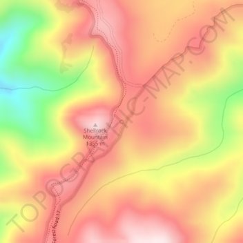
Nombre: Mapa topográfico Shellrock Spring, altitud, relieve.
Altitud media: 1,157 m
Altitud mínima: 853 m
Altitud máxima: 1,345 m
Otros mapas topográficos
Haga clic en un mapa para ver su topografía, su altitud y su relieve.
Hood River
United States > Oregon > Hood River County
Hood River, Hood River County, Oregon, United States
Altitud media: 112 m
Parkdale
United States > Oregon > Hood River County > Parkdale
Parkdale, Hood River County, Oregon, United States
Altitud media: 538 m
Odell
United States > Oregon > Hood River County
Odell, Hood River County, Oregon, United States
Altitud media: 244 m
Badger Lake Dam
United States > Oregon > Hood River County
Badger Lake Dam, Hood River County, Oregon, United States
Altitud media: 1,565 m
Government Cove
United States > Oregon > Hood River County > Cascade Locks
Government Cove, Cascade Locks, Hood River County, Oregon, United States
Altitud media: 89 m
Cascade Locks Marine Park
United States > Oregon > Hood River County > Cascade Locks
Cascade Locks Marine Park, Cascade Locks, Hood River County, Oregon, United States
Altitud media: 72 m
Mount Hood
United States > Oregon > Hood River County
Mount Hood, Hood River County, Oregon, United States
Altitud media: 2,716 m
Dee
United States > Oregon > Hood River County
Dee, Hood River County, Oregon, United States
Altitud media: 424 m
Columbia River
United States > Oregon > Hood River County > Cascade Locks
Columbia River, Cascade Locks, Hood River County, Oregon, United States
Altitud media: 543 m
Cascade Locks
United States > Oregon > Hood River County
Cascade Locks, Hood River County, Oregon, United States
Altitud media: 101 m