
Mapa topográfico Orange City
Mapa interactivo
Haga clic en el mapa para ver la altitud.
Acerca de este mapa
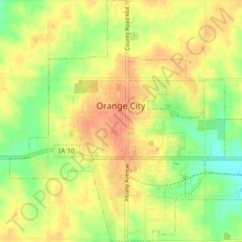
Nombre: Mapa topográfico Orange City, altitud, relieve.
Lugar: Orange City, Sioux County, Iowa, United States (42.98212 -96.08640 43.02672 -96.02719)
Altitud media: 427 m
Altitud mínima: 403 m
Altitud máxima: 443 m
Otros mapas topográficos
Haga clic en un mapa para ver su topografía, su altitud y su relieve.
Sioux Center
United States > Iowa > Sioux County
Sioux Center, Sioux County, Iowa, 51250, United States
Altitud media: 433 m
Chatsworth
United States > Iowa > Sioux County > Chatsworth
Chatsworth, Sioux County, Iowa, 51011, United States
Altitud media: 357 m