
Mapa topográfico Sioux Center
Mapa interactivo
Haga clic en el mapa para ver la altitud.
Acerca de este mapa
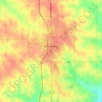
Nombre: Mapa topográfico Sioux Center, altitud, relieve.
Lugar: Sioux Center, Sioux County, Iowa, 51250, United States (43.04430 -96.19566 43.10895 -96.14569)
Altitud media: 433 m
Altitud mínima: 398 m
Altitud máxima: 453 m
Sioux Center is at an elevation of 1,445 feet (440 m) above sea level. It lies near the north-to-south ridge, or spine, of western Iowa. The eastern side of Sioux Center drains to the Floyd River. The western side drains to the Big Sioux River. This "divide" is profoundly unnoticeable. The area within a ten-mile (16 km) radius of Sioux Center has been divided into sections of one square mile each. The gravel and paved roads marking the sections do not swerve or contour for the slight hills or valleys.
Otros mapas topográficos
Haga clic en un mapa para ver su topografía, su altitud y su relieve.
Orange City
United States > Iowa > Sioux County
Orange City, Sioux County, Iowa, United States
Altitud media: 427 m
Chatsworth
United States > Iowa > Sioux County > Chatsworth
Chatsworth, Sioux County, Iowa, 51011, United States
Altitud media: 357 m