
Mapa topográfico The Peaks
Mapa interactivo
Haga clic en el mapa para ver la altitud.
Acerca de este mapa
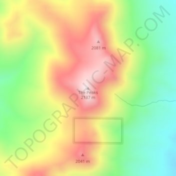
Nombre: Mapa topográfico The Peaks, altitud, relieve.
Lugar: The Peaks, Harney County, Oregon, United States of America (42.38270 -118.70028 42.38280 -118.70018)
Altitud media: 1,825 m
Altitud mínima: 1,551 m
Altitud máxima: 2,127 m
Otros mapas topográficos
Haga clic en un mapa para ver su topografía, su altitud y su relieve.
Cascade Range
United States of America > Oregon
Cascade Range, Marion County, Oregon, United States of America
Altitud media: 690 m
Springfield
United States of America > Oregon > Springfield > Springfield
Springfield, Lane County, Oregon, 97477-2635, United States of America
Altitud media: 226 m
Washington Park
United States of America > Oregon > Portland
Washington Park, 4033, Arlington Heights, Portland, Multnomah County, Oregon, 97221, United States of America
Altitud media: 169 m
Necanicum River
United States of America > Oregon
Necanicum River, Clatsop County, Oregon, 97138, United States of America
Altitud media: 185 m
Imnaha River Woods Development
United States of America > Oregon > Imnaha River Woods Development
Imnaha River Woods Development, Wallowa County, Oregon, United States of America
Altitud media: 1,331 m
Crescent Lake
United States of America > Oregon > Crescent Lake
Odell Lake, Crescent Lake, Klamath County, Oregon, United States of America
Altitud media: 1,492 m
Pine Point
United States of America > Oregon
Pine Point, Curry County, Oregon, United States of America
Altitud media: 353 m
The Villages at Mount Hood
United States of America > Oregon
The Villages at Mount Hood, Clackamas County, Oregon, United States of America
Altitud media: 797 m
Charleston
United States of America > Oregon > Charleston
Charleston, Coos County, Oregon, United States of America
Altitud media: 24 m
Riddle
United States of America > Oregon > Riddle
Riddle, Douglas County, Oregon, United States of America
Altitud media: 246 m
Scholls
United States of America > Oregon > Scholls
Scholls, Washington County, Oregon, United States of America
Altitud media: 52 m
Buxton
United States of America > Oregon > Buxton
Buxton, Washington County, Oregon, 97125, United States of America
Altitud media: 146 m
Iron Knob
United States of America > Oregon
Iron Knob, Jackson County, Oregon, United States of America
Altitud media: 861 m
Cape Blanco
United States of America > Oregon
Cape Blanco, Cape Blanco Road, Curry County, Oregon, United States of America
Altitud media: 9 m
Tierra Del Mar
United States of America > Oregon > Tierra Del Mar
Tierra Del Mar, Tillamook County, Oregon, 97135, United States of America
Altitud media: 67 m
Horse Ridge
United States of America > Oregon
Horse Ridge, Deschutes County, Oregon, United States of America
Altitud media: 1,390 m
Table Rock
United States of America > Oregon > Brookings
Table Rock, Brookings, Curry County, Oregon, 97415, United States of America
Altitud media: 242 m
Lebanon Dam
United States of America > Oregon
Lebanon Dam, Linn County, Oregon, United States of America
Altitud media: 149 m
Boring
United States of America > Oregon > Boring
Boring, Clackamas County, Oregon, 97009, United States of America
Altitud media: 183 m
Upper Highland
United States of America > Oregon > Upper Highland
Upper Highland, Clackamas County, Oregon, United States of America
Altitud media: 365 m
Tick Hill
United States of America > Oregon
Tick Hill, Wallowa County, Oregon, 97885, United States of America
Altitud media: 990 m
Tillamook
United States of America > Oregon > Tillamook > Tillamook
Tillamook, Tillamook County, Oregon, United States of America
Altitud media: 4 m