
Mapa topográfico Calgary
Mapa interactivo
Haga clic en el mapa para ver la altitud.
Acerca de este mapa
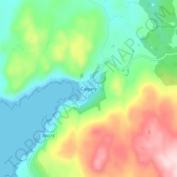
Nombre: Mapa topográfico Calgary, altitud, relieve.
Lugar: Calgary, Argyll and Bute, Scotland, PA75 6QU, United Kingdom (56.55891 -6.29676 56.59891 -6.25676)
Altitud media: 109 m
Altitud mínima: 0 m
Altitud máxima: 318 m
Otros mapas topográficos
Haga clic en un mapa para ver su topografía, su altitud y su relieve.
Lismore
United Kingdom > Scotland > Argyll and Bute > Achnacroish
The island of Lismore lies in Loch Linnhe, north east of Mull, in the Argyll and Bute council area. It is 15 kilometres (9.3 mi) long and about 2 kilometres (1.2 mi) wide and oriented from SW to NE, roughly parallel to the Great Glen Fault. To the east is an arm of Loch Linnhe known as the Lynn of Lorn.…
Altitud media: 16 m
Castle Sween
United Kingdom > Scotland > Argyll and Bute > Achnamara > Kilmichael of Inverlussa
Altitud media: 55 m
Gigha
United Kingdom > Scotland > Argyll and Bute > Ardminish
Gigha lies 5 kilometres (3 mi) off the coast of Kintyre and is 9.5 km (6 mi) long in a roughly north-south direction and a maximum of 2.5 km (1 1⁄2 mi) wide. The total area is 1,395 hectares (3,450 acres) and the highest elevation of Creag Bhàn reaches only 100 m (330 ft). The rocky central spine is…
Altitud media: 3 m
Loch Sunart to the Sound of Jura Marine Protected Area
United Kingdom > Scotland > Argyll and Bute
Altitud media: 135 m