
Mapa topográfico Orkney Islands
Haga clic en el mapa para ver la altitud.
Orkney Islands
The southern group of islands surrounds Scapa Flow. Hoy, to the west, is the second largest of the Orkney Isles and Ward Hill at its northern end is the highest elevation in the archipelago. The Old Man of Hoy is a well-known seastack. Graemsay and Flotta are both linked by ferry to the Mainland and Hoy, and the latter is known for its large oil terminal. South Walls has a 19th-century Martello tower and is connected to Hoy by the Ayre. Burray lies to the east of Scapa Flow and is linked by causeway to South Ronaldsay, which hosts cultural events such as the Festival of the Horse and the Boys' Ploughing Match on the third Saturday in August. It is also the location of the Neolithic Tomb of the Eagles. South Ronaldsay, Burray, Glimps Holm, and Lamb Holm are connected by road to the Mainland by the Churchill Barriers.
Acerca de este mapa
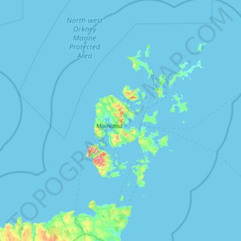
Nombre: Mapa topográfico Orkney Islands, altitud, relieve.
Lugar: Orkney Islands, Scotland, United Kingdom (58.67299 -4.50725 59.39974 -2.36801)
Altitud media: 7 m
Altitud mínima: 0 m
Altitud máxima: 460 m
Otros mapas topográficos
Haga clic en un mapa para ver su topografía, su altitud y su relieve.
Edinburgh
United Kingdom > Scotland > Edinburgh
Some have called Edinburgh the Athens of the North for a variety of reasons. The earliest comparison between the two cities showed that they had a similar topography, with the Castle Rock of Edinburgh performing a similar role to the Athenian Acropolis. Both of them had flatter, fertile agricultural land…
Altitud media: 104 m
Fort William
United Kingdom > Scotland > Highland
Fort William has an oceanic climate (Cfb) with moderate, but generally cool, temperatures and abundant precipitation. In the towns immediate vicinity, there are significant variations in elevation, which leads to some uninhabited areas near the town having a subpolar oceanic climate (Cfc), or, at the absolute…
Altitud media: 122 m
Mull of Kintyre
Ailsa Craig and the County Antrim coast of Ulster and Rathlin Island are all clearly visible from the Mull. On clearer days it is also possible to make out Malin Head in Inishowen in County Donegal in the west of Ulster, and the Ayrshire coast on the other side of Ailsa Craig. Other islands in the Firth of…
Altitud media: 84 m
Scottish Highlands
United Kingdom > Scotland > Highland
The Scottish Highlands are renowned for their rugged, mountainous terrain that dominates much of the region. Stretching across the northern and central parts of Scotland, the landscape is shaped by ancient geological forces, including the Caledonian Orogeny, which caused significant tectonic collisions…
Altitud media: 907 m
Aberdeen
United Kingdom > Scotland > Aberdeen
Two weather stations collect climate data for the area, Aberdeen/Dyce Airport, and Craibstone. Both are about 4 1⁄2 miles (7 km) to the north west of the city centre, and given that they are in close proximity to each other, exhibit very similar climatic regimes. Dyce tends to have marginally warmer daytime…
Altitud media: 52 m
Bathgate
United Kingdom > Scotland > West Lothian
In the 1846 book A Topographical Dictionary of Scotland, Samuel Lewis writes.
Altitud media: 167 m
Glasgow
United Kingdom > Scotland > Glasgow City
Glasgow itself was reputed to have been founded by the Christian missionary Saint Mungo in the 6th century. He established a church on the Molendinar Burn, where the present Glasgow Cathedral stands, and in the following years Glasgow became a religious centre. Glasgow grew over the following centuries. The…
Altitud media: 128 m
Newtonmore
United Kingdom > Scotland > Highland
Newtonmore is located within the Cairngorms National Park, approximately 3 miles (5 km) southwest of Kingussie and 15 miles (24 km) southwest of Aviemore. It is on the northeastern bank of the River Spey, between the River Calder and the Allt Lairaidh, at an altitude of approximately 250 metres (820 ft).
Altitud media: 283 m
Stonebyres
United Kingdom > Scotland > South Lanarkshire > Nemphlar > Upper Cairnie
Altitud media: 158 m
Ben Nevis
United Kingdom > Scotland > Highland
Ben Nevis has a highland (alpine) maritime (oceanic) polar climate (ET climate in the Köppen classification). Ben Nevis's elevation, maritime location and topography frequently lead to cool and cloudy weather conditions, which can pose a danger to ill-equipped walkers. According to the observations carried…
Altitud media: 912 m
Ailsa Craig
In a small glen above Ailsa Castle, a small freshwater body known as the Garry Loch is located at an altitude of 247 m (810 ft), with a depth of at least 17 feet.
Altitud media: 14 m
Dundee
United Kingdom > Scotland > Dundee City
Dundee sits on the north bank of the Firth of Tay on the eastern, North Sea Coast of Scotland. The city lies 36.1 miles (58 km) NNE of Edinburgh and 360.6 miles (580 km) NNW of London. The built-up area occupies a roughly rectangular shape 8.3 miles (13 km) long by 2.5 miles (4 km) wide, aligned in an east to…
Altitud media: 82 m
Montrose
United Kingdom > Scotland > Angus
Montrose occupies a position on the North Bank of Montrose Basin at the mouth of the River South Esk on the East Coast of Scotland, 11 miles (18 km) NNE of Arbroath, 19 miles (31 km) SW of Stonehaven, and 7.2 miles (12 km) ESE of Brechin. The town lies 62.2 miles (100 km) NNE of Edinburgh, and 373.2 miles (601…
Altitud media: 22 m
Coatbridge
United Kingdom > Scotland > North Lanarkshire
The topography of Coatbridge was an important feature in the town's development during the industrial revolution. Coatbridge rests 60 metres below the "Slamannan plateau" and neighbouring Airdrie sits on its edge. The low-lying flat ground of Coatbridge was a vital factor in the siting of the town's blast…
Altitud media: 100 m
Glen Shee
United Kingdom > Scotland > Perth and Kinross > Spittal of Glenshee
The A93 road, part of General Wade's military road from Perth to Fort George, runs north through the glen and on into Glen Beag, where it crosses the Cairnwell Pass, which at an elevation of 2,200 feet (670 metres) is the highest public road in the UK. The road climbing to the summit is now wide and straight…
Altitud media: 387 m
Denholm
United Kingdom > Scotland > Scottish Borders
In Main Street, stands The Text House, a category B listed building, erected about 1910 by John Haddon (1845–1924), a medical doctor and author of published works on public sanitation and dietetics. The 3-storey house is in the arts and craft style. One of the texts on the front elevation is a reminder to…
Altitud media: 128 m
Invergarry Castle
United Kingdom > Scotland > Highland > Invergarry
The survey drawing shows a plan and elevations of the castle, called the 'Castle of Glangary' on the drawing. The drawing may appear misleading, as more than one facade is joined together, but by cross-referencing the lettering on the plan to the elevations the appearance can be judged.
Altitud media: 150 m
Fort Augustus
United Kingdom > Scotland > Highland
As with most of the British Isles and Scotland, Fort Augustus has an oceanic climate (Köppen: Cfb) with cool summers and mild winters. Like a lot of the surrounding area, sunshine levels are low at around 1,005 hours per annum and temperatures are unpredictable – Fort Augustus holds the UK's joint lowest…
Altitud media: 115 m
Glen Coe
United Kingdom > Scotland > Highland > Glencoe
Habitats within Glen Coe include birch woodland, moorland and peatbogs. The upland parts of the glen are one of the best habitats for alpine and sub-alpine plants in Lochaber, due to the underlying geology and range of altitude. Typical plants found on the highest slopes of the glen include lady's mantle,…
Altitud media: 415 m