Geolocalizar

Mapa topográfico Khangchendzonga National Park

Mapa interactivo

Haga clic en el mapa para ver la altitud.

Acerca de este mapa

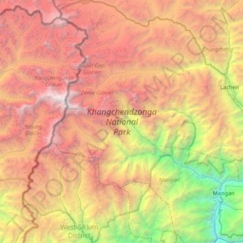
Nombre: Mapa topográfico Khangchendzonga National Park, altitud, relieve.

Lugar: Khangchendzonga National Park, North Sikkim Highway, Mangan, North Sikkim District, Sikkim, India (27.39267 88.04354 27.91868 88.62545)

Altitud media: 4,330 m

Altitud mínima: 599 m

Altitud máxima: 8,521 m

The Kanchenjunga Park is situated in the North and West Sikkim districts in the Indian state of Sikkim. It has an elevation of 1,829 metres (6,001 ft) to over 8,550 metres (28,050 ft) and has an area of 849.50 km2 (327.99 sq mi). It is one of the few high-altitude National parks of India and was recently included as a mixed-criteria UNESCO World Heritage site.

Otros mapas topográficos

Haga clic en un mapa para ver su topografía, su altitud y su relieve.

Danfebir

India > Sikkim > Gyalshing

Danfebir, Gyalshing, Gyalshing District, Sikkim, India

Altitud media: 4,330 m

Gangtok

India > Sikkim > Gangtok > Gangtok

Gangtok, East Sikkim District, Sikkim, 737101, India

Altitud media: 1,911 m

Kupup

India > Sikkim

Kupup, Gangtok district, Sikkim, India

Altitud media: 4,007 m

East Sikkim District

India > Sikkim > Pakyong subdivision

East Sikkim District, Pakyong subdivision, Pakyong district, Sikkim, India

Altitud media: 2,107 m

Gyalshing

India > Sikkim

Gyalshing, West Sikkim District, Sikkim, India

Altitud media: 3,139 m

West District

India > Sikkim

West District, West Sikkim District, Sikkim, 737111, India

Altitud media: 2,636 m

Lachung

India > Sikkim > Chungthang

Lachung, Chungthang, Mangan District, Sikkim, India

Altitud media: 3,617 m

Gangtok district

India > Sikkim

Gangtok district, Sikkim, India

Altitud media: 2,334 m

Mangan

India > Sikkim

Mangan, Mangan District, Sikkim, India

Altitud media: 3,312 m

East District

India > Sikkim > East District

East District, East Sikkim District, Sikkim, India

Altitud media: 2,740 m

Soreng

India > Sikkim

Soreng, Soreng District, Sikkim, India

Altitud media: 1,620 m

Pelling

India > Sikkim > Gyalshing > Pelling

Pelling, Gyalshing, West Sikkim District, Sikkim, 737113, India

Altitud media: 1,552 m

Zemu Glacier

India > Sikkim

Zemu Glacier, North District, North Sikkim District, Sikkim, India

Altitud media: 5,499 m

Jorethang

India > Sikkim > Namchi > Jorethang

Jorethang, Namchi, South Sikkim District, Sikkim, India

Altitud media: 723 m

Namchi

India > Sikkim

Namchi, Namchi District, Sikkim, India

Altitud media: 1,040 m

Rumtek

India > Sikkim > Rumtek

Rumtek, Gangtok, East Sikkim District, Sikkim, 737102, India

Altitud media: 1,374 m

Ravangla

India > Sikkim > Ravong

Ravangla, Ravong, Namchi District, Sikkim, 737139, India

Altitud media: 1,870 m

South District

India > Sikkim

South District, South Sikkim District, Sikkim, India

Altitud media: 2,676 m

North District

India > Sikkim

North District, North Sikkim District, Sikkim, India

Altitud media: 3,760 m