
Haz una donación
Mapa topográfico Haiterbach
Haga clic en el mapa para ver la altitud.
Haz una donación
Haiterbach
The township of (Stadt) of Haiterbach is located at the southern tipof the district of Calw, along its border with the district of Freudenstadt to the south. Haiterbach is physically located in the greater Black Forest region and the Heckengäu, with some of its municipal area lying in the Upper Gäu [de] to the north and east. The landscape of Haiterbach's municipal area is defined by the Waldach and its tributaries. Elevation above sea level in the municipal area ranges from a high of 678 meters (2,224 ft) Normalnull (NN) to a low of 428 meters (1,404 ft) NN.
Haz una donación
Acerca de este mapa
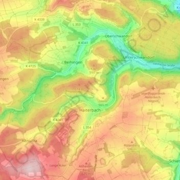
Nombre: Mapa topográfico Haiterbach, altitud, relieve.
Altitud media: 563 m
Altitud mínima: 406 m
Altitud máxima: 698 m
Haz una donación
Otros mapas topográficos
Haga clic en un mapa para ver su topografía, su altitud y su relieve.
Bad Teinach
Germany > Baden-Württemberg > Landkreis Calw
The township (Stadt) of Bad Teinach-Zavelstein is located at the center of the district of Calw, in Baden-Württemberg, one of the 16 States of the Federal Republic of Germany. Bad Teinach-Zavelstein's municipal area rests upon the plateau of the Enz and Nagold rivers, a landscape defined by severe river…
Altitud media: 557 m
Zieflensberg
Germany > Baden-Württemberg > Landkreis Calw > Bad Herrenalb > Zieflensberg
Altitud media: 668 m
Haz una donación