
Haz una donación
Mapa topográfico Bad Teinach
Haga clic en el mapa para ver la altitud.
Haz una donación
Bad Teinach
The township (Stadt) of Bad Teinach-Zavelstein is located at the center of the district of Calw, in Baden-Württemberg, one of the 16 States of the Federal Republic of Germany. Bad Teinach-Zavelstein's municipal area rests upon the plateau of the Enz and Nagold rivers, a landscape defined by severe river erosion, in the greater Black Forest region. Elevation above sea level in the municipal area ranges from a high of 747 meters (2,451 ft) Normalnull (NN) to a low of 337 meters (1,106 ft) NN.
Haz una donación
Acerca de este mapa
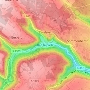
Nombre: Mapa topográfico Bad Teinach, altitud, relieve.
Altitud media: 557 m
Altitud mínima: 363 m
Altitud máxima: 657 m
Haz una donación
Otros mapas topográficos
Haga clic en un mapa para ver su topografía, su altitud y su relieve.
Calw
Germany > Baden-Württemberg > Landkreis Calw
Calw is located in the valley of the Nagold in the Northern Black Forest at an altitude between 330 and 630 metres (1,080–2,070 ft) above sea level. The historic centre lies west of the river. The newer parts of town have developed on the surrounding slopes. The following streams also exist within the town:…
Altitud media: 540 m
Bad Liebenzell
Germany > Baden-Württemberg > Landkreis Calw
Bad Liebenzell lies to the West of the Centre of Baden-Württemberg in Nagold. The village has an elevation of 310 (Monbachtal) to 687 Metern (Gemarkung Maisenbach-Zainen) and is part of the Nature Park Schwarzwald Mitte/Nord. The City Bad Liebenzell include the former Municipalities Möttlingen, Möttlingen,…
Altitud media: 534 m
Haiterbach
Germany > Baden-Württemberg > Landkreis Calw
The township of (Stadt) of Haiterbach is located at the southern tipof the district of Calw, along its border with the district of Freudenstadt to the south. Haiterbach is physically located in the greater Black Forest region and the Heckengäu, with some of its municipal area lying in the Upper Gäu [de] to…
Altitud media: 563 m
Haz una donación
Enzklösterle
Germany > Baden-Württemberg > Landkreis Calw
The municipality (Gemeinde) of Enzklösterle is situated on the western edge of the district of Calw, along the border with the districts of Freudenstadt and Rastatt to the west. Enzklösterle is physically located in the valley of the Großen Enz, in the Northern Black Forest and Grinde regions. Elevation…
Altitud media: 782 m
Gültlingen
Germany > Baden-Württemberg > Landkreis Calw > Wildberg
The township (Stadt) of Wildberg is situated on the eastern edge of the district of Calw, in the German state of Baden-Württemberg, and lies along the border with the district of Böblingen to the east. Wildberg is physically located in the valley of the Nagold, between the Northern Black Forest to the west…
Altitud media: 525 m
Haz una donación
Unterreichenbach
Germany > Baden-Württemberg > Landkreis Calw
Unterreichenbach is in the Nagold River Valley between Calw and Pforzheim, at an altitude of between 292 und 633 metres.
Altitud media: 493 m
Haz una donación
Dobel
Germany > Baden-Württemberg > Landkreis Calw
The municipality (Gemeinde) of Dobel is located situated in the district of Calw, in the German state of Baden-Württemberg. Dobel lies at the northwest corner of the district, bordering the districts of Rastatt and the Enz. The municipal area is physically located in the Grinde area of the Black Forest, on a…
Altitud media: 658 m