
Haz una donación
Mapa topográfico Enzklösterle
Haga clic en el mapa para ver la altitud.
Haz una donación
Enzklösterle
The municipality (Gemeinde) of Enzklösterle is situated on the western edge of the district of Calw, along the border with the districts of Freudenstadt and Rastatt to the west. Enzklösterle is physically located in the valley of the Großen Enz, in the Northern Black Forest and Grinde regions. Elevation above sea level in the municipal area ranges from a high of 924 meters (3,031 ft) Normalnull (NN) at the top of the Hirschkopf to a low of 563 meters (1,847 ft) NN.
Haz una donación
Acerca de este mapa
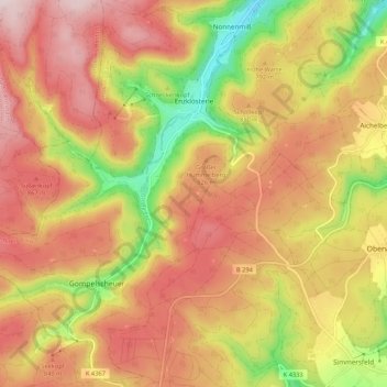
Nombre: Mapa topográfico Enzklösterle, altitud, relieve.
Altitud media: 782 m
Altitud mínima: 554 m
Altitud máxima: 950 m
Haz una donación
Otros mapas topográficos
Haga clic en un mapa para ver su topografía, su altitud y su relieve.
Zieflensberg
Germany > Baden-Württemberg > Landkreis Calw > Bad Herrenalb > Zieflensberg
Altitud media: 668 m
Bad Teinach
Germany > Baden-Württemberg > Landkreis Calw
The township (Stadt) of Bad Teinach-Zavelstein is located at the center of the district of Calw, in Baden-Württemberg, one of the 16 States of the Federal Republic of Germany. Bad Teinach-Zavelstein's municipal area rests upon the plateau of the Enz and Nagold rivers, a landscape defined by severe river…
Altitud media: 557 m
Haz una donación