
Haz una donación
Mapa topográfico Unterreichenbach
Haga clic en el mapa para ver la altitud.
Haz una donación
Unterreichenbach
Unterreichenbach is in the Nagold River Valley between Calw and Pforzheim, at an altitude of between 292 und 633 metres.
Haz una donación
Acerca de este mapa
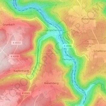
Nombre: Mapa topográfico Unterreichenbach, altitud, relieve.
Altitud media: 493 m
Altitud mínima: 289 m
Altitud máxima: 651 m
Haz una donación
Otros mapas topográficos
Haga clic en un mapa para ver su topografía, su altitud y su relieve.
Bad Teinach
Germany > Baden-Württemberg > Landkreis Calw
The township (Stadt) of Bad Teinach-Zavelstein is located at the center of the district of Calw, in Baden-Württemberg, one of the 16 States of the Federal Republic of Germany. Bad Teinach-Zavelstein's municipal area rests upon the plateau of the Enz and Nagold rivers, a landscape defined by severe river…
Altitud media: 557 m
Zieflensberg
Germany > Baden-Württemberg > Landkreis Calw > Bad Herrenalb > Zieflensberg
Altitud media: 668 m
Haz una donación