Geolocalizar

Mapa topográfico Thoreau

Mapa interactivo

Haga clic en el mapa para ver la altitud.

Acerca de este mapa

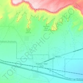
Nombre: Mapa topográfico Thoreau, altitud, relieve.

Lugar: Thoreau, McKinley County, New Mexico, 87323, United States (35.38735 -108.27384 35.45973 -108.18253)

Altitud media: 2,253 m

Altitud mínima: 2,138 m

Altitud máxima: 2,591 m

Thoreau is located at an altitude of approximately 2,200 meters (7,200 feet) above sea level, and 8 kilometers (5.0 mi) east of the continental divide. Thoreau is located in a broad valley beneath a large escarpment of Entrada sandstone, which marks the southern boundary of the Colorado Plateau to the north. Mount Powell and Castle Rock are landmarks along this escarpment adjacent to Thoreau. The Zuñi Mountains are to the south.

Wikipedia (CC-BY-SA 3.0)

Otros mapas topográficos

Haga clic en un mapa para ver su topografía, su altitud y su relieve.

Gallup

United States > New Mexico > McKinley County

Gallup, McKinley County, New Mexico, 87301, United States

Altitud media: 2,067 m

Zuni Pueblo

United States > New Mexico > McKinley County

Zuni Pueblo, McKinley County, New Mexico, 87327, United States

Altitud media: 1,931 m

Littlewater

United States > New Mexico > McKinley County

Littlewater, Eastern Navajo Agency, McKinley County, New Mexico, United States

Altitud media: 2,082 m

Crownpoint

United States > New Mexico > McKinley County

Crownpoint, Eastern Navajo Agency, McKinley County, New Mexico, 87313, United States

Altitud media: 2,099 m

Pinedale

United States > New Mexico > McKinley County

Pinedale, Eastern Navajo Agency, McKinley County, New Mexico, United States

Altitud media: 2,154 m

Navajo

United States > New Mexico > McKinley County

Navajo, Fort Defiance Agency, McKinley County, New Mexico, 87328, United States

Altitud media: 2,203 m

Prewitt Lake

United States > New Mexico > McKinley County

Prewitt Lake, McKinley County, New Mexico, United States

Altitud media: 2,393 m

Nahodishgish

United States > New Mexico > McKinley County

Nahodishgish, Eastern Navajo Agency, McKinley County, New Mexico, United States

Altitud media: 2,061 m

Continental Divide

United States > New Mexico > McKinley County

Continental Divide, McKinley County, New Mexico, 87312, United States

Altitud media: 2,221 m

Ramah

United States > New Mexico > McKinley County

Ramah, Eastern Navajo Agency, McKinley County, New Mexico, United States

Altitud media: 2,184 m

Eastern Navajo Agency

United States > New Mexico > McKinley County

Eastern Navajo Agency, McKinley County, New Mexico, United States

Altitud media: 2,005 m

Pueblo Pintado

United States > New Mexico > McKinley County > Pueblo Pintado

Pueblo Pintado, Navajo Route 7008, Pueblo Pintado, Eastern Navajo Agency, McKinley County, New Mexico, United States

Altitud media: 1,981 m

Smith Lake

United States > New Mexico > McKinley County

Smith Lake, Eastern Navajo Agency, McKinley County, New Mexico, United States

Altitud media: 2,221 m

Tinian

United States > New Mexico > McKinley County

Tinian, Eastern Navajo Agency, McKinley County, New Mexico, United States

Altitud media: 2,014 m