
Gracias por apoyar a este sitio ❤️
Haz una donación
Haz una donación
Mapa topográfico Littlewater
Haga clic en el mapa para ver la altitud.
Gracias por apoyar a este sitio ❤️
Haz una donación
Haz una donación
Acerca de este mapa
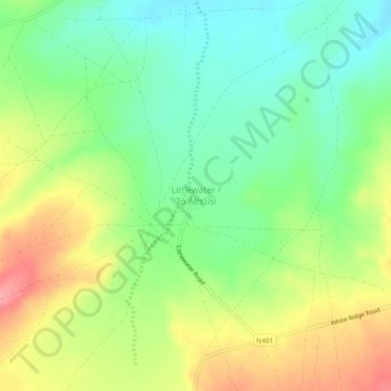
Nombre: Mapa topográfico Littlewater, altitud, relieve.
Altitud media: 2,082 m
Altitud mínima: 2,041 m
Altitud máxima: 2,139 m
Gracias por apoyar a este sitio ❤️
Haz una donación
Haz una donación
Otros mapas topográficos
Haga clic en un mapa para ver su topografía, su altitud y su relieve.
Thoreau
United States > New Mexico > McKinley County
Thoreau is located at an altitude of approximately 2,200 meters (7,200 feet) above sea level, and 8 kilometers (5.0 mi) east of the continental divide. Thoreau is located in a broad valley beneath a large escarpment of Entrada sandstone, which marks the southern boundary of the Colorado Plateau to the north.…
Altitud media: 2,253 m
Gracias por apoyar a este sitio ❤️
Haz una donación
Haz una donación