
Mapa topográfico Kennesaw Mountain
Mapa interactivo
Haga clic en el mapa para ver la altitud.
Acerca de este mapa
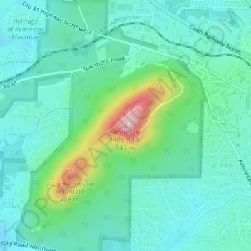
Nombre: Mapa topográfico Kennesaw Mountain, altitud, relieve.
Altitud media: 360 m
Altitud mínima: 310 m
Altitud máxima: 532 m
Kennesaw Mountain is a mountain between Marietta and Kennesaw, Georgia in the United States with a summit elevation of 1,808 feet (551 m). It is the highest point in the core (urban and suburban) metro Atlanta area, and fifth after further-north exurban counties are considered. The local terrain averages roughly 1,000 feet (300 m) AMSL.
Otros mapas topográficos
Haga clic en un mapa para ver su topografía, su altitud y su relieve.
Vinings
United States > Georgia > Cobb County
Vinings, Cobb County, Georgia, 30339, United States
Altitud media: 281 m
Kennesaw
United States > Georgia > Cobb County
Kennesaw, Cobb County, Georgia, 30144, United States
Altitud media: 317 m
North Georgia Fairgrounds Lake Dam
United States > Georgia > Cobb County
North Georgia Fairgrounds Lake Dam, Cobb County, Georgia, 30008, United States
Altitud media: 313 m
Lost Mountain Park
United States > Georgia > Cobb County
Lost Mountain Park, Cobb County, Georgia, United States
Altitud media: 343 m
Austell
United States > Georgia > Cobb County
Austell, Cobb County, Georgia, United States
Altitud media: 289 m
Acworth
United States > Georgia > Cobb County
Acworth, Cobb County, Georgia, United States
Altitud media: 281 m
Clarkdale
United States > Georgia > Cobb County
Clarkdale, Cobb County, Georgia, 30111, United States
Altitud media: 281 m
Marietta
United States > Georgia > Cobb County
Marietta, Cobb County, Georgia, United States
Altitud media: 323 m
Smyrna
United States > Georgia > Cobb County
Smyrna, Cobb County, Georgia, United States
Altitud media: 289 m
Fair Oaks
United States > Georgia > Cobb County
Fair Oaks, Cobb County, Georgia, United States
Altitud media: 329 m
Powder Springs
United States > Georgia > Cobb County
Powder Springs, Cobb County, Georgia, United States
Altitud media: 291 m
Mableton
United States > Georgia > Cobb County
Mableton, Cobb County, Georgia, 30126, United States
Altitud media: 298 m
Austell
United States > Georgia > Cobb County > Austell
Austell, Cobb County, Georgia, 30001, United States
Altitud media: 283 m
Kennesaw
United States > Georgia > Cobb County > Kennesaw
Kennesaw, Cobb County, Georgia, 30144, United States
Altitud media: 318 m
Viking Quarry Lake
United States > Georgia > Cobb County
Viking Quarry Lake, Cobb County, Georgia, United States
Altitud media: 303 m
Lost Mountain
United States > Georgia > Cobb County
Lost Mountain, Cobb County, Georgia, United States
Altitud media: 340 m
Marietta
United States > Georgia > Cobb County > Marietta
Marietta, Cobb County, Georgia, 30090, United States
Altitud media: 302 m
Acworth
United States > Georgia > Cobb County > Acworth
Acworth, Cobb County, Georgia, 30101, United States
Altitud media: 280 m
Sweetwater Creek
United States > Georgia > Cobb County > Douglasville
Sweetwater Creek, Douglasville, Cobb County, Georgia, 30122, United States
Altitud media: 287 m