
Mapa topográfico Kent Ridge Park
Mapa interactivo
Haga clic en el mapa para ver la altitud.
Acerca de este mapa
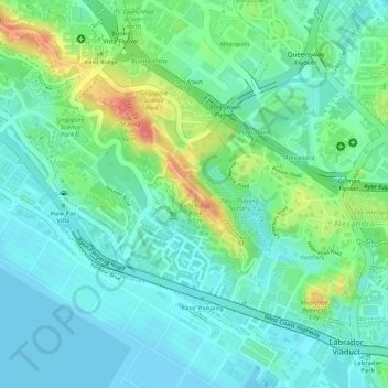
Nombre: Mapa topográfico Kent Ridge Park, altitud, relieve.
Lugar: Kent Ridge Park, Queenstown, Southwest, Singapore (1.27778 103.78567 1.28910 103.79575)
Altitud media: 21 m
Altitud mínima: 0 m
Altitud máxima: 67 m
Otros mapas topográficos
Haga clic en un mapa para ver su topografía, su altitud y su relieve.
Jurong Hill Park
Jurong Hill Park, Boon Lay, Southwest, Singapore
Altitud media: 11 m
Pandan Reservoir
Singapore > Southwest > Jurong East
Pandan Reservoir, Jurong East, Southwest, Singapore
Altitud media: 6 m
Jurong River
Singapore > Southwest > Jurong East
Jurong River, Jurong East, Southwest, Singapore
Altitud media: 7 m
Clementi Woods
Clementi Woods, Clementi, Southwest, Singapore
Altitud media: 15 m
Yunnan Park
Yunnan Park, Yunnan, Jurong West, Southwest, Singapore
Altitud media: 19 m
Sungei Buloh Wetland Reserve
Singapore > Southwest > Singapore
Sungei Buloh Wetland Reserve, 301, Neo Tiew Crescent, Lim Chu Kang, Singapore, Southwest, 718925, Singapore
Altitud media: 6 m
One-North Park
One-North Park, Queenstown, Southwest, Singapore
Altitud media: 25 m
Tanjong Pasir Laba
Tanjong Pasir Laba, Western Water Catchment, Southwest, 639937, Singapore
Altitud media: 4 m