
Mapa topográfico Ploiești
Mapa interactivo
Haga clic en el mapa para ver la altitud.
Acerca de este mapa
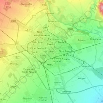
Nombre: Mapa topográfico Ploiești, altitud, relieve.
Lugar: Ploiești, Prahova, Romania (44.89614 25.91790 44.96842 26.10197)
Altitud media: 158 m
Altitud mínima: 105 m
Altitud máxima: 264 m
The city lies on the Wallachian Plain, having an average altitude of 150 m (490 ft). The surrounding landscape is influenced by its position around the Prahova River, whose stream bed lies 25 km (16 mi) to the west. The Teleajen River passes through the city while the Dâmbu River passes through the north-eastern neighbourhoods.
Otros mapas topográficos
Haga clic en un mapa para ver su topografía, su altitud y su relieve.
Valea Călugărească
Romania > Prahova > Valea Călugărească
Valea Călugărească, Prahova, Romania
Altitud media: 154 m