
Mapa topográfico Bușteni
Mapa interactivo
Haga clic en el mapa para ver la altitud.
Acerca de este mapa
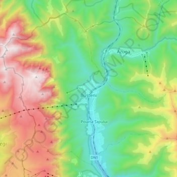
Nombre: Mapa topográfico Bușteni, altitud, relieve.
Lugar: Bușteni, Prahova, Romania (45.36783 25.45256 45.47040 25.62365)
Altitud media: 1,419 m
Altitud mínima: 807 m
Altitud máxima: 2,500 m
Bușteni (Romanian pronunciation: [buʃˈtenʲ]) is a small mountain town in the north of Prahova County, Muntenia, Romania. It is located in the Prahova Valley, at the bottom of the Bucegi Mountains, that have a maximum altitude of 2,505 m (8,219 ft). Its name literally means tree-logs in Romanian. One village, Poiana Țapului, is administratively part of the town, formerly a separate commune prior to 1950. According to the 2021 census, it has 8,368 inhabitants.
Otros mapas topográficos
Haga clic en un mapa para ver su topografía, su altitud y su relieve.
Valea Călugărească
Romania > Prahova > Valea Călugărească
Valea Călugărească, Prahova, Romania
Altitud media: 154 m