
Mapa topográfico Ettumanoor
Mapa interactivo
Haga clic en el mapa para ver la altitud.
Acerca de este mapa
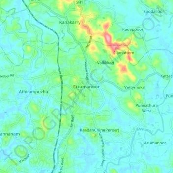
Nombre: Mapa topográfico Ettumanoor, altitud, relieve.
Lugar: Ettumanoor, Kottayam, Kerala, 686631, India (9.63018 76.51778 9.71018 76.59778)
Altitud media: 22 m
Altitud mínima: -1 m
Altitud máxima: 123 m
Otros mapas topográficos
Haga clic en un mapa para ver su topografía, su altitud y su relieve.
Sankranthi
India > Kerala > Kottayam > Kottayam
Sankranthi, Kumaranalloor, Kottayam, Kerala, 686028, India
Altitud media: 15 m
Thiruvanchoor
India > Kerala > Kottayam > Thiruvanchoor
Thiruvanchoor, Kottayam, Kerala, 686032, India
Altitud media: 11 m
Illickal Thazhe
India > Kerala > Kottayam > Kozhikombu > Illickal Thazhe
Illickal Thazhe, Kozhikombu, Kottayam, Kerala, 686635, India
Altitud media: 46 m