
Haz una donación
Mapa topográfico Bad Hersfeld
Haga clic en el mapa para ver la altitud.
Haz una donación
Bad Hersfeld
The Flugplatz Johannesberg has the status of Special Airfield. The runway, some 671 m long and 18 m wide, is paved with asphalt and oriented in a north–south direction. The airfield lies on the Johannesberg in the like-named outlying centre at an elevation of 284 m above sea level.
Haz una donación
Acerca de este mapa
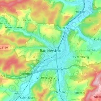
Nombre: Mapa topográfico Bad Hersfeld, altitud, relieve.
Altitud media: 281 m
Altitud mínima: 193 m
Altitud máxima: 466 m
Haz una donación
Otros mapas topográficos
Haga clic en un mapa para ver su topografía, su altitud y su relieve.
Bad Hersfeld
Germany > Hesse > Landkreis Hersfeld-Rotenburg
The Flugplatz Johannesberg has the status of Special Airfield. The runway, some 671 m long and 18 m wide, is paved with asphalt and oriented in a north–south direction. The airfield lies on the Johannesberg in the like-named outlying centre at an elevation of 284 m above sea level.
Altitud media: 305 m
Haz una donación
Hohenroda
Germany > Hesse > Landkreis Hersfeld-Rotenburg
The municipality lies between the Rhön and the Thuringian Forest (ranges) in the so-called Kuppen Rhön. The highest elevation in the Hessian Skittles (a range of volcanic mountains), the Soisberg, stands at the western municipal limits.
Altitud media: 341 m
Haz una donación