
Haz una donación
Mapa topográfico Narrows Wash
Haga clic en el mapa para ver la altitud.
Haz una donación
Acerca de este mapa
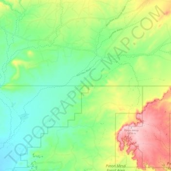
Nombre: Mapa topográfico Narrows Wash, altitud, relieve.
Lugar: Narrows Wash, San Juan County, New Mexico, United States (36.82181 -108.37598 36.87883 -108.26223)
Altitud media: 1,708 m
Altitud mínima: 1,610 m
Altitud máxima: 1,883 m
Haz una donación
Otros mapas topográficos
Haga clic en un mapa para ver su topografía, su altitud y su relieve.
Navajo Lake State Park
United States > New Mexico > San Juan County > Navajo Dam
Altitud media: 1,966 m
Haz una donación
Haz una donación
Haz una donación
Aztec
United States > New Mexico > San Juan County > Aztec > Aztec
Yet another area managed by the BLM, this area was formed about the same time as the Bisti and Ah-Shi-Sle-Pah. This region offers a uniquely different scale of landscape. Hoodoo in this region are massive and the terrain much greater in elevation differences, thereby exposing a greater geological time frame…
Altitud media: 1,767 m