
Gracias por apoyar a este sitio ❤️
Haz una donación
Haz una donación
Mapa topográfico Sanostee
Haga clic en el mapa para ver la altitud.
Gracias por apoyar a este sitio ❤️
Haz una donación
Haz una donación
Acerca de este mapa
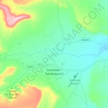
Nombre: Mapa topográfico Sanostee, altitud, relieve.
Altitud media: 1,850 m
Altitud mínima: 1,777 m
Altitud máxima: 2,032 m
Gracias por apoyar a este sitio ❤️
Haz una donación
Haz una donación
Otros mapas topográficos
Haga clic en un mapa para ver su topografía, su altitud y su relieve.
Lake Farmington Recreation Area
United States > New Mexico > San Juan County > Farmington
Altitud media: 1,723 m
Gracias por apoyar a este sitio ❤️
Haz una donación
Haz una donación
Gracias por apoyar a este sitio ❤️
Haz una donación
Haz una donación
Aztec
United States > New Mexico > San Juan County > Aztec > Aztec
Yet another area managed by the BLM, this area was formed about the same time as the Bisti and Ah-Shi-Sle-Pah. This region offers a uniquely different scale of landscape. Hoodoo in this region are massive and the terrain much greater in elevation differences, thereby exposing a greater geological time frame…
Altitud media: 1,767 m
Gracias por apoyar a este sitio ❤️
Haz una donación
Haz una donación