
Haz una donación
Mapa topográfico Zwingenberg
Haga clic en el mapa para ver la altitud.
Haz una donación
Zwingenberg
Zwingenberg lies on the western edge of the Odenwald at the foot of the Melibokus, at 517.4 m above sea level the Bergstraße's highest mountain. The municipal area's elevation varies between roughly 90 m above sea level in the outlying centre of Rodau and just under 300 m on the slope of the Melibokus. Zwingenberg's highest elevation is no one single mountain. Rather, it runs along the Melibokus's slope into the area of Auerbach, an outlying centre of Bensheim. The 100-metre marker at Zwingenberg railway station is taken to be the standard. In the west, Zwingenberg abuts the Hessisches Ried, and thereby the Rhine rift.
Haz una donación
Acerca de este mapa
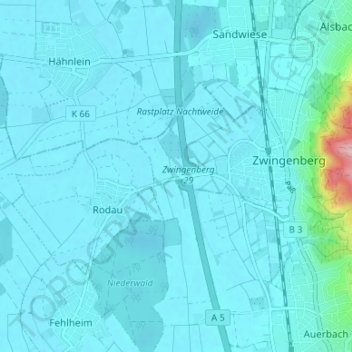
Nombre: Mapa topográfico Zwingenberg, altitud, relieve.
Lugar: Zwingenberg, Kreis Bergstraße, Hesse, 64673, Germany (49.71129 8.56049 49.73428 8.62693)
Altitud media: 104 m
Altitud mínima: 89 m
Altitud máxima: 283 m
Haz una donación
Otros mapas topográficos
Haga clic en un mapa para ver su topografía, su altitud y su relieve.
Wald-Michelbach
Germany > Hesse > Kreis Bergstraße > Wald-Michelbach > Wald-Michelbach
Altitud media: 396 m