
Mapa topográfico Timișoara
Mapa interactivo
Haga clic en el mapa para ver la altitud.
Acerca de este mapa
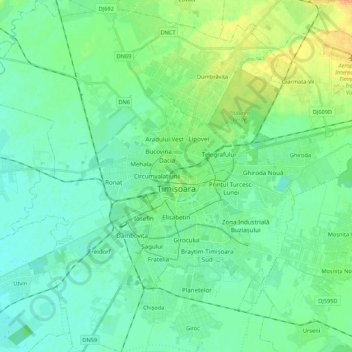
Nombre: Mapa topográfico Timișoara, altitud, relieve.
Lugar: Timișoara, Timiș, Romania (45.68383 21.11168 45.83417 21.32717)
Altitud media: 92 m
Altitud mínima: 83 m
Altitud máxima: 113 m
Timișoara lies at an altitude of 90 metres on the southeast edge of the Banat Plain, part of the Pannonian Plain, near the divergence of the Timiș and Bega rivers. The waters of the two rivers form a swampy and frequently flooded land. Timișoara developed on one of few places where the swamps could be crossed. These constituted a natural protection around the fortress for a very long time and favored a wet and insalubrious climate, which spread plague and cholera and kept the number of inhabitants relatively low, preventing civic development. With time, these rivers were drained, dammed and diverted. Due to the hydrographical projects undertaken in the 18th century, the city no longer lies on the Timiș River, but on the Bega Canal. This improvement of the land was made irreversible by building the Bega Canal (started in 1728) and by the complete draining of the surrounding marshes. The city lies only 0.5 to 5 metres above the water table, which disallows the construction of tall buildings. The rich black soil and relatively high water table make this a fertile agricultural region.
Otros mapas topográficos
Haga clic en un mapa para ver su topografía, su altitud y su relieve.