
Mapa topográfico Ramakrishna Puram
Mapa interactivo
Haga clic en el mapa para ver la altitud.
Acerca de este mapa
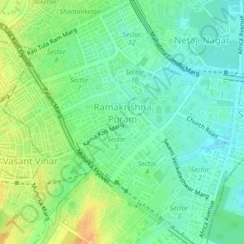
Nombre: Mapa topográfico Ramakrishna Puram, altitud, relieve.
Altitud media: 235 m
Altitud mínima: 222 m
Altitud máxima: 254 m
Otros mapas topográficos
Haga clic en un mapa para ver su topografía, su altitud y su relieve.
Vasant Kunj
Vasant Kunj, Vasant Vihar Tehsil, New Delhi, Delhi, India
Altitud media: 261 m
Central Ridge Reserve Forest
Central Ridge Reserve Forest, Delhi Cantonment, New Delhi, Delhi, India
Altitud media: 235 m
Chanakyapuri
Chanakyapuri, Chanakya Puri Tehsil, New Delhi, Delhi, 110021, India
Altitud media: 228 m
Vasant Vihar
Vasant Vihar, Delhi Cantonment, New Delhi, Delhi, 110057, India
Altitud media: 244 m
Lodhi Gardens
Lodhi Gardens, Rabindra Nagar, New Delhi, Chanakya Puri Tehsil, Delhi, India
Altitud media: 214 m