
Haz una donación
Mapa topográfico Bigge
Haga clic en el mapa para ver la altitud.
Haz una donación
Acerca de este mapa
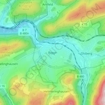
Nombre: Mapa topográfico Bigge, altitud, relieve.
Altitud media: 410 m
Altitud mínima: 305 m
Altitud máxima: 649 m
Haz una donación
Otros mapas topográficos
Haga clic en un mapa para ver su topografía, su altitud y su relieve.
Winterberg
Germany > North Rhine-Westphalia > Hochsauerlandkreis
Winterberg experiences a humid continental climate (Köppen Dfb) like most of Germany, however also bordering on subarctic climate (Dfc), thanks to its altitude, with only having one average temperature above 10 °C and September only being barely above it. The summers are short and cool, while the winters are…
Altitud media: 628 m
Winterberg
Germany > North Rhine-Westphalia > Hochsauerlandkreis
Winterberg experiences a humid continental climate (Köppen Dfb) like most of Germany, however also bordering on subarctic climate (Dfc), thanks to its altitude, with only having an average temperature above 10 °C and September only being barely above it. The summers are short and cool, while the winters are…
Altitud media: 627 m
Haz una donación
Haz una donación
Winterberg
Germany > North Rhine-Westphalia > Hochsauerlandkreis
Winterberg experiences a humid continental climate (Köppen Dfb) like most of Germany, however also bordering on subarctic climate (Dfc), thanks to its altitude, with only having an average temperature above 10 °C and September only being barely above it. The summers are short and cool, while the winters are…
Altitud media: 628 m
Brilon
Germany > North Rhine-Westphalia > Hochsauerlandkreis
Brilon is situated on the Brilon Heights at an altitude of about 450 m on the upper reaches of the river Möhne. The town lies between the Arnsberg Forest nature reserve to the west and the Lake Diemel nature reserve and the Hoppecke to the south-east.
Altitud media: 472 m
Haz una donación
Haz una donación