
Haz una donación
Mapa topográfico Brilon
Haga clic en el mapa para ver la altitud.
Haz una donación
Brilon
Brilon is situated on the Brilon Heights at an altitude of about 450 m on the upper reaches of the river Möhne. The town lies between the Arnsberg Forest nature reserve to the west and the Lake Diemel nature reserve and the Hoppecke to the south-east.
Haz una donación
Acerca de este mapa
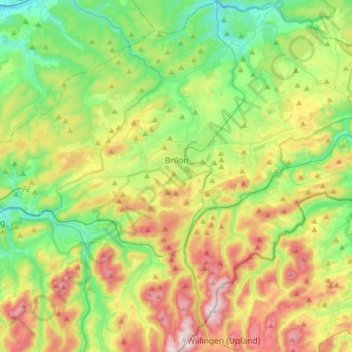
Nombre: Mapa topográfico Brilon, altitud, relieve.
Altitud media: 472 m
Altitud mínima: 279 m
Altitud máxima: 811 m
Haz una donación
Otros mapas topográficos
Haga clic en un mapa para ver su topografía, su altitud y su relieve.
Ruhrquelle
Germany > North Rhine-Westphalia > Hochsauerlandkreis > Winterberg > Grönebach
Altitud media: 645 m
Lenneplätze
Germany > North Rhine-Westphalia > Hochsauerlandkreis > Winterberg > Neuastenberg
Altitud media: 699 m
Gellinghausen
Germany > North Rhine-Westphalia > Hochsauerlandkreis > Schmallenberg > Westernbödefeld
Altitud media: 565 m
Haz una donación
Haz una donación
Haz una donación
Haz una donación