Geolocalizar

Mapa topográfico Hebrides

Haga clic en el mapa para ver la altitud.

Acerca de este mapa

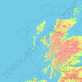
Nombre: Mapa topográfico Hebrides, altitud, relieve.

Lugar: Hebrides, Scotland, United Kingdom (55.57907 -7.69746 58.51960 -5.42703)

Altitud media: 94 m

Altitud mínima: -1 m

Altitud máxima: 1,254 m

Otros mapas topográficos

Haga clic en un mapa para ver su topografía, su altitud y su relieve.

Edinburgh

United Kingdom > Scotland > Edinburgh

Some have called Edinburgh the Athens of the North for a variety of reasons. The earliest comparison between the two cities showed that they had a similar topography, with the Castle Rock of Edinburgh performing a similar role to the Athenian Acropolis. Both of them had flatter, fertile agricultural land…

Altitud media: 104 m

Glasgow

United Kingdom > Scotland > Glasgow City

Glasgow itself was reputed to have been founded by the Christian missionary Saint Mungo in the 6th century. He established a church on the Molendinar Burn, where the present Glasgow Cathedral stands, and in the following years Glasgow became a religious centre. Glasgow grew over the following centuries. The…

Altitud media: 128 m

Inverness

United Kingdom > Scotland > Highland

Altitud media: 163 m

Ben Nevis

United Kingdom > Scotland > Highland

Ben Nevis has a highland (alpine) maritime (oceanic) polar climate (ET climate in the Köppen classification). Ben Nevis's elevation, maritime location and topography frequently lead to cool and cloudy weather conditions, which can pose a danger to ill-equipped walkers. According to the observations carried…

Altitud media: 912 m

Fort William

United Kingdom > Scotland > Highland

Fort William has an oceanic climate (Cfb) with moderate, but generally cool, temperatures and abundant precipitation. In the towns immediate vicinity, there are significant variations in elevation, which leads to some uninhabited areas near the town having a subpolar oceanic climate (Cfc), or, at the absolute…

Altitud media: 122 m

Dundee

United Kingdom > Scotland > Dundee City

Dundee sits on the north bank of the Firth of Tay on the eastern, North Sea Coast of Scotland. The city lies 36.1 miles (58 km) NNE of Edinburgh and 360.6 miles (580 km) NNW of London. The built-up area occupies a roughly rectangular shape 8.3 miles (13 km) long by 2.5 miles (4 km) wide, aligned in an east to…

Altitud media: 82 m

Aberdeen

United Kingdom > Scotland > Aberdeen

Two weather stations collect climate data for the area, Aberdeen/Dyce Airport, and Craibstone. Both are about 4 1⁄2 miles (7 km) to the north west of the city centre, and given that they are in close proximity to each other, exhibit very similar climatic regimes. Dyce tends to have marginally warmer daytime…

Altitud media: 52 m

Ballater

United Kingdom > Scotland > Aberdeenshire

Ballater (/ˈbælətər/, Scottish Gaelic: Bealadair) is a village in Aberdeenshire, Scotland, on the River Dee, immediately east of the Cairngorm Mountains. Situated at an elevation of 213 metres (699 feet), Ballater is a centre for hikers and known for its spring water, once said to cure scrofula. It is home…

Altitud media: 360 m

Ben Loyal

United Kingdom > Scotland > Highland

Altitud media: 441 m

Cairneyhill

United Kingdom > Scotland > Fife

Altitud media: 49 m

Ben Hope

United Kingdom > Scotland > Highland

Altitud media: 490 m

Ben Klibreck

United Kingdom > Scotland > Highland

Ben Klibreck (Scottish Gaelic: Beinn Chlìbric) is a Scottish mountain located in central Sutherland. It is an isolated mountain, rising above a large area of moorland. The highest point, Meall nan Con (the mound of the dogs), rises to 962 metres (3,156 ft) elevation and is therefore the second most northerly…

Altitud media: 551 m

Quinag

United Kingdom > Scotland > Highland

Altitud media: 368 m

Canisp

United Kingdom > Scotland > Highland

Canisp is an isolated mountain that stands in the Glencanisp Forest, a large rock and water wilderness. It has a topographic prominence of 691 metres (2,267 ft). Canisp has little vegetation, even on its lower slopes large areas of Gneiss (one of the oldest rocks in the world) are visible on the surface.

Altitud media: 467 m

Foinaven

United Kingdom > Scotland > Highland

Altitud media: 552 m

Ben Hee

United Kingdom > Scotland > Highland

Altitud media: 612 m

Loch Veyatie

United Kingdom > Scotland > Highland

Altitud media: 248 m

Argyll and Bute

United Kingdom > Scotland

Altitud media: 683 m

Greens

United Kingdom > Scotland > Aberdeenshire

Altitud media: 122 m

Inverness-shire

United Kingdom > Scotland

Altitud media: 333 m

Glasgow

United Kingdom > Scotland > Glasgow City

Glasgow itself was reputed to have been founded by the Christian missionary Saint Mungo in the 6th century. He established a church on the Molendinar Burn, where the present Glasgow Cathedral stands, and in the following years Glasgow became a religious centre. Glasgow grew over the following centuries as part…

Altitud media: 128 m

Aberlour

United Kingdom > Scotland > Moray

According to the 1846 A Topographical Dictionary of Scotland, "This parish, formerly called Skirdustan, signifying, in the Gaelic tongue, 'the division of Dustan', its tutelary saint, derived its present name from its situation at the mouth of a noisy burn, which discharges itself into the river Spey."

Altitud media: 160 m

Forres

United Kingdom > Scotland > Moray

Altitud media: 31 m

Paisley

United Kingdom > Scotland > Renfrewshire

Altitud media: 33 m

Airdrie

United Kingdom > Scotland > North Lanarkshire

Airdrie's name first appeared in the Register of the Great Seal of Scotland (Registrum Magni Sigilii Regum Scotorum) in 1373 as Ardre. By 1546 it had become Ardry and by 1587 it was known as Ardrie. In 1630 it finally appeared in the Register as Airdrie. Given the topography of the area, the most likely…

Altitud media: 135 m

Largs

United Kingdom > Scotland > North Ayrshire

Altitud media: 110 m

Banffshire

United Kingdom > Scotland

Altitud media: 191 m

Mull of Kintyre

United Kingdom > Scotland

Ailsa Craig and the County Antrim coast of Ulster and Rathlin Island are all clearly visible from the Mull. On clearer days it is also possible to make out Malin Head in Inishowen in County Donegal in the west of Ulster, and the Ayrshire coast on the other side of Ailsa Craig. Other islands in the Firth of…

Altitud media: 84 m

Balerno

United Kingdom > Scotland > Balerno

Altitud media: 194 m

River Kerry

United Kingdom > Scotland

Altitud media: 118 m

Sgùrr na Stri

United Kingdom > Scotland

Altitud media: 92 m

Loch Urigill

United Kingdom > Scotland

Altitud media: 172 m

Bonnybridge

United Kingdom > Scotland > Falkirk

Altitud media: 84 m

Stenhousemuir

United Kingdom > Scotland > Falkirk

Altitud media: 34 m

Kelty

United Kingdom > Scotland > Fife

Altitud media: 154 m

The Minch

United Kingdom > Scotland

Altitud media: 63 m

Ben More Coigach

United Kingdom > Scotland > Highland

Ben Mor Coigach (Scottish Gaelic: Beinn Mhòr na Còigich) is the highest point along a ridge rising steeply from Loch Broom, in the far northwest of Scotland. It rises above the Coigach peninsula in the county of Ross and Cromarty, 10 kilometres northwest of Ullapool, reaching a height of 743 metres (2,438…

Altitud media: 452 m

Ben More Assynt

United Kingdom > Scotland > Highland

In 2012, the Commonwealth War Graves Commission decided to replace the existing cairn, which had deteriorated in the harsh climate, with a 600-kilogramme granite marker to identify and protect the burial site. At an elevation of around 600 m (2,000 ft), the burial site on Ben More Assynt is one of the…

Altitud media: 677 m

Aviemore

United Kingdom > Scotland > Highland

Altitud media: 331 m

Coatbridge

United Kingdom > Scotland > North Lanarkshire

The topography of Coatbridge was an important feature in the town's development during the industrial revolution. Coatbridge rests 60 metres below the "Slamannan plateau" and neighbouring Airdrie sits on its edge. The low-lying flat ground of Coatbridge was a vital factor in the siting of the town's blast…

Altitud media: 100 m

Western Isles

United Kingdom > Scotland

Altitud media: 23 m

Ayrshire

United Kingdom > Scotland

Altitud media: 141 m

Inchmickery

United Kingdom > Scotland

Altitud media: 0 m

Ailsa Craig

United Kingdom > Scotland

In a small glen above Ailsa Castle, a small freshwater body known as the Garry Loch is located at an altitude of 247 m (810 ft), with a depth of at least 17 feet.

Altitud media: 14 m

Iona

United Kingdom > Scotland

Altitud media: 9 m

Stirlingshire

United Kingdom > Scotland

Altitud media: 222 m

Glen Dochart

United Kingdom > Scotland

Altitud media: 469 m

Denton Burn

United Kingdom > Scotland

Altitud media: 154 m

Taynish Island

United Kingdom > Scotland

Altitud media: 11 m

Meall Aundrary

United Kingdom > Scotland

Altitud media: 194 m

Burian Hole

United Kingdom > Scotland

Altitud media: 36 m

Papa

United Kingdom > Scotland

Altitud media: 2 m

Braid Hill

United Kingdom > Scotland

Altitud media: 353 m

Highland

United Kingdom > Scotland

Altitud media: 402 m

Glen Croe

United Kingdom > Scotland

Altitud media: 355 m

Snap

United Kingdom > Scotland

Altitud media: 3 m

Lanarkshire

United Kingdom > Scotland

Altitud media: 183 m

Oban

United Kingdom > Scotland > Argyll and Bute

Altitud media: 52 m

Schiehallion

United Kingdom > Scotland > Perth and Kinross

Schiehallion lies between Loch Tay, Loch Rannoch and Loch Tummel, about 10 miles (16 kilometres) to the west-north-west of Aberfeldy in Perthshire. The mountain, with an elevation of 1,083 metres (3,553 ft), is isolated from other peaks and has an almost perfectly conical shape from the west. The view of the…

Altitud media: 652 m

Penicuik

United Kingdom > Scotland > Midlothian

Altitud media: 247 m

Cumbernauld

United Kingdom > Scotland > North Lanarkshire > Cumbernauld

Cumbernauld's name probably comes from the Gaelic comar nan allt, meaning "meeting of the burns or streams". There are differing views as to the etymology of this. One theory is that from its high point in the Central Belt, its streams flow both west to the River Clyde and east to the Firth of Forth so…

Altitud media: 111 m

Leuchars

United Kingdom > Scotland > Fife

Altitud media: 22 m