
Haz una donación
Mapa topográfico Pla de Mallorca
Haga clic en el mapa para ver la altitud.
Haz una donación
Acerca de este mapa
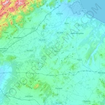
Nombre: Mapa topográfico Pla de Mallorca, altitud, relieve.
Lugar: Pla de Mallorca, Balearic Islands, Spain (39.46030 2.80613 39.81538 3.25144)
Altitud media: 145 m
Altitud mínima: -3 m
Altitud máxima: 1,432 m
Haz una donación
Otros mapas topográficos
Haga clic en un mapa para ver su topografía, su altitud y su relieve.
Paseo Marítimo de la Bahia de Sant Antoni de Portmany
Spain > Balearic Islands > Ibiza > Sant Antoni de Portmany
Altitud media: 11 m
Serra de Tramuntana
Spain > Balearic Islands > Serra de Tramuntana
The climate in the Tramuntana Range is significantly wetter than the rest of the island, recording as much as 1507 mm (59.3 inches) of precipitation per year, in comparison with some other parts of the island where annual rainfall is less than 400mm (15 inch). It is also cooler due to the altitude, and a few…
Altitud media: 175 m
Haz una donación
Puig Major
Spain > Balearic Islands > Serra de Tramuntana > Escorca
Puig Major is the highest peak on the Spanish island of Majorca. With an elevation of 1,436 m (4,711 ft) above sea level. It is situated in the Serra de Tramuntana mountains. As the mountain is located in a military zone, the neighbouring peak Puig de Massanella (1,364 m) is considered the highest accessible…
Altitud media: 949 m
Haz una donación
Haz una donación
Mirador d'es Colomer
Spain > Balearic Islands > Serra de Tramuntana > Port de Pollença
Altitud media: 79 m
Haz una donación
Haz una donación
Urbanització Puig de Can Vinyets
Spain > Balearic Islands > Ibiza > Santa Eulària des Riu
Altitud media: 32 m
Haz una donación
Haz una donación
Haz una donación
Haz una donación
Haz una donación
Cala Grassio
Spain > Balearic Islands > Ibiza > Sant Antoni de Portmany > Can Germà > Cap Negret
Altitud media: 23 m
Haz una donación
Serra de Tramuntana
Spain > Balearic Islands > Serra de Tramuntana
The climate in the Tramuntana Range is significantly wetter than the rest of the island, recording as much as 1507 mm (59.3 inches) of precipitation per year, in comparison with some other parts of the island where annual rainfall is less than 400mm (15 inch). It is also cooler due to the altitude, and a few…
Altitud media: 175 m
Haz una donación
Haz una donación
Haz una donación
Haz una donación
Haz una donación