
Gracias por apoyar a este sitio ❤️
Haz una donación
Haz una donación
Mapa topográfico St. Johann
Haga clic en el mapa para ver la altitud.
Gracias por apoyar a este sitio ❤️
Haz una donación
Haz una donación
Acerca de este mapa
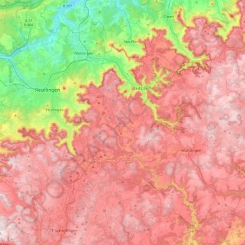
Nombre: Mapa topográfico St. Johann, altitud, relieve.
Altitud media: 644 m
Altitud mínima: 281 m
Altitud máxima: 900 m
Gracias por apoyar a este sitio ❤️
Haz una donación
Haz una donación
Otros mapas topográficos
Haga clic en un mapa para ver su topografía, su altitud y su relieve.
Gracias por apoyar a este sitio ❤️
Haz una donación
Haz una donación
Ableitung Erms
Germany > Baden-Württemberg > Landkreis Reutlingen > Dettingen an der Erms
Altitud media: 482 m
Gracias por apoyar a este sitio ❤️
Haz una donación
Haz una donación
Gracias por apoyar a este sitio ❤️
Haz una donación
Haz una donación
Lichtenstein
Germany > Baden-Württemberg > Landkreis Reutlingen
The municipality (Gemeinde) of Lichtenstein covers 34.24 square kilometres (13.22 sq mi) of the Reutlingen district, in the state of the Federal Republic of Germany. It is physically located in the middle of the Swabian Jura, on the edge of the Middle Kuppenalb [de] in the valley of the river Echaz. Elevation…
Altitud media: 689 m