
Haz una donación
Mapa topográfico Lichtenstein
Haga clic en el mapa para ver la altitud.
Haz una donación
Lichtenstein
The municipality (Gemeinde) of Lichtenstein covers 34.24 square kilometres (13.22 sq mi) of the Reutlingen district, in the state of the Federal Republic of Germany. It is physically located in the middle of the Swabian Jura, on the edge of the Middle Kuppenalb [de] in the valley of the river Echaz. Elevation above sea level ranges from 466 meters (1,529 ft) to 836 meters (2,743 ft) Normalnull.
Haz una donación
Acerca de este mapa
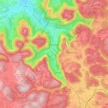
Nombre: Mapa topográfico Lichtenstein, altitud, relieve.
Altitud media: 689 m
Altitud mínima: 428 m
Altitud máxima: 863 m
Haz una donación
Otros mapas topográficos
Haga clic en un mapa para ver su topografía, su altitud y su relieve.
Ableitung Erms
Germany > Baden-Württemberg > Landkreis Reutlingen > Dettingen an der Erms
Altitud media: 482 m
Haz una donación
Untergreifenstein
Germany > Baden-Württemberg > Landkreis Reutlingen > Lichtenstein
Altitud media: 661 m
Haz una donación