
Mapa topográfico Three Sisters Wilderness
Mapa interactivo
Haga clic en el mapa para ver la altitud.
Acerca de este mapa
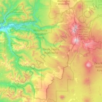
Nombre: Mapa topográfico Three Sisters Wilderness, altitud, relieve.
Altitud media: 1,391 m
Altitud mínima: 345 m
Altitud máxima: 3,133 m
The Three Sisters Wilderness ranges in elevation from 2,000 to 10,363 feet (610 to 3,159 m). The Three Sisters—North Sister at 10,090 feet (3,075 m), Middle Sister at 10,052 feet (3,064 m), and South Sister at 10,363 feet (3,159 m) — are found in the eastern portion of the Wilderness. Including Broken Top—just to the south at 9,175 feet (2,797 m) — there are 14 glaciers offering one of the best examples of the effects of glaciation in the Pacific Northwest. Collier Glacier, between North and Middle Sister, is the largest glacier in Oregon. The headwaters of the Wild and Scenic Whychus Creek (formerly Squaw Creek) emerge in the Wilderness.
Otros mapas topográficos
Haga clic en un mapa para ver su topografía, su altitud y su relieve.
Eugene
United States > Oregon > Lane County
Eugene, Lane County, Oregon, United States
Altitud media: 163 m
Florence
United States > Oregon > Lane County
Florence, Lane County, Oregon, United States
Altitud media: 22 m
Cheshire
United States > Oregon > Lane County > Cheshire
Cheshire, Lane County, Oregon, 97419, United States
Altitud media: 109 m
Pleasant Hill
United States > Oregon > Lane County
Pleasant Hill, Lane County, Oregon, 97455, United States
Altitud media: 183 m
Leaburg
United States > Oregon > Lane County
Leaburg, Lane County, Oregon, United States
Altitud media: 355 m
Mapleton
United States > Oregon > Lane County
Mapleton, Lane County, Oregon, 97453, United States
Altitud media: 131 m
McKenzie River
United States > Oregon > Lane County > Rainbow
McKenzie River, Rainbow, Lane County, Oregon, 97413, United States
Altitud media: 431 m
Dorena Lake
United States > Oregon > Lane County
Dorena Lake, Lane County, Oregon, United States
Altitud media: 331 m
Cheshire
United States > Oregon > Lane County
Cheshire, Lane County, Oregon, United States
Altitud media: 109 m
Oakridge
United States > Oregon > Lane County
Oakridge, Lane County, Oregon, United States
Altitud media: 465 m
Waldo Lake Wilderness
United States > Oregon > Lane County
Waldo Lake Wilderness, Lane County, Oregon, United States
Altitud media: 1,528 m
Coburg
United States > Oregon > Lane County
Coburg, Lane County, Oregon, 97408, United States
Altitud media: 120 m
Cottage Grove
United States > Oregon > Lane County
Cottage Grove, Lane County, Oregon, 97424, United States
Altitud media: 230 m
Swisshome
United States > Oregon > Lane County
Swisshome, Lane County, Oregon, 97480, United States
Altitud media: 222 m
McKenzie River
United States > Oregon > Lane County
McKenzie River, Lane County, Oregon, United States
Altitud media: 698 m
Veneta
United States > Oregon > Lane County
Veneta, Lane County, Oregon, 97487, United States
Altitud media: 133 m
Westfir
United States > Oregon > Lane County
Westfir, Lane County, Oregon, 47492, United States
Altitud media: 442 m
Disston
United States > Oregon > Lane County
Disston, Lane County, Oregon, United States
Altitud media: 512 m
Lowell
United States > Oregon > Lane County
Lowell, Lane County, Oregon, 97452, United States
Altitud media: 261 m
Marcola
United States > Oregon > Lane County
Marcola, Lane County, Oregon, United States
Altitud media: 223 m
Elmira
United States > Oregon > Lane County > Elmira
Elmira, Lane County, Oregon, United States
Altitud media: 120 m
Washington/Jefferson City Park
United States > Oregon > Lane County > Eugene
Washington/Jefferson City Park, Eugene, Lane County, Oregon, United States
Altitud media: 130 m
Rainbow
United States > Oregon > Lane County
Rainbow, Lane County, Oregon, 97413, United States
Altitud media: 486 m
Noti
United States > Oregon > Lane County > Noti
Noti, Lane County, Oregon, 97461, United States
Altitud media: 201 m
West Bank City Park
United States > Oregon > Lane County > Eugene
West Bank City Park, Bethel, Eugene, Lane County, Oregon, United States
Altitud media: 125 m
Springfield
United States > Oregon > Lane County
Springfield, Lane County, Oregon, United States
Altitud media: 177 m
Walton
United States > Oregon > Lane County
Walton, Lane County, Oregon, United States
Altitud media: 231 m
Cupit Mary Mountain
United States > Oregon > Lane County
Cupit Mary Mountain, Lane County, Oregon, United States
Altitud media: 1,702 m
Dorena
United States > Oregon > Lane County > Dorena
Dorena, Lane County, Oregon, 97434, United States
Altitud media: 434 m
Culp Creek
United States > Oregon > Lane County > Culp Creek
Culp Creek, Lane County, Oregon, 97434, United States
Altitud media: 474 m
Saddle Camp Butte
United States > Oregon > Lane County
Saddle Camp Butte, Lane County, Oregon, United States
Altitud media: 973 m
Junction City
United States > Oregon > Lane County
Junction City, Lane County, Oregon, United States
Altitud media: 102 m
McKenzie Bridge
United States > Oregon > Lane County
McKenzie Bridge, Lane County, Oregon, 97413, United States
Altitud media: 521 m
Waldo Lake
United States > Oregon > Lane County
Waldo Lake, Lane County, Oregon, United States
Altitud media: 1,687 m
Mount Popocatepetl
United States > Oregon > Lane County
Mount Popocatepetl, Lane County, Oregon, United States
Altitud media: 163 m
Dexter
United States > Oregon > Lane County
Dexter, Lane County, Oregon, 97431, United States
Altitud media: 240 m
Creswell
United States > Oregon > Lane County
Creswell, Lane County, Oregon, 97426, United States
Altitud media: 165 m
Fuji Mountain
United States > Oregon > Lane County
Fuji Mountain, Lane County, Oregon, United States
Altitud media: 1,885 m