
Haz una donación
Mapa topográfico Bayan Lepas
Haga clic en el mapa para ver la altitud.
Haz una donación
Acerca de este mapa
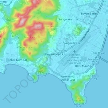
Nombre: Mapa topográfico Bayan Lepas, altitud, relieve.
Lugar: Bayan Lepas, George Town, South-West, Penang, 11960, Malaysia (5.25481 100.21960 5.33481 100.29960)
Altitud media: 51 m
Altitud mínima: -1 m
Altitud máxima: 403 m
Haz una donación
Otros mapas topográficos
Haga clic en un mapa para ver su topografía, su altitud y su relieve.
Haz una donación
Haz una donación
Haz una donación
Paya Terubong
Malaysia > Penang > George Town
The subdivision of Paya Terubong covers an area of 32.7 km2 (12.6 sq mi), forming a corridor that stretches from the central valleys of Penang Island to Jerejak Island off the eastern coast. It encompasses a varied topography and includes several neighbourhoods, namely Farlim, Bukit Jambul, Sungai Dua, Batu…
Altitud media: 129 m
Haz una donación
Haz una donación
Haz una donación
Haz una donación
Penang Hill
Malaysia > Penang > George Town > Ayer Itam
A number of hills are covered by Penang Hill, with the highest point being Western Hill that stands at an altitude of 833 meters (2,733 feet) above sea level. Penang Hill is a hilly and forested area that stands out from the lowlands of Malaysia by being hilly and wooded. The area was used as a retreat during…
Altitud media: 436 m
Penang National Park
Malaysia > Penang > George Town
There are two major trails in the Park, leading to Muka Head lighthouse and Pantai Kerachut respectively. The trail branches of at Pasir Pandak Hut. The trail leading to Muka Head lighthouse stops at Teluk Tukun, where it branches off to the canopy walkway, where it then links to Pantai Kerachut or vice versa.…
Altitud media: 86 m
Haz una donación
Haz una donación