Geolocalizar

Mapa topográfico Kenichira

Mapa interactivo

Haga clic en el mapa para ver la altitud.

Acerca de este mapa

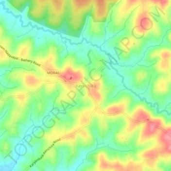
Nombre: Mapa topográfico Kenichira, altitud, relieve.

Lugar: Kenichira, Sulthanbathery, Wayanad District, Kerala, 673596, India (11.70311 76.13240 11.74311 76.17240)

Altitud media: 770 m

Altitud mínima: 731 m

Altitud máxima: 818 m

Otros mapas topográficos

Haga clic en un mapa para ver su topografía, su altitud y su relieve.

Edakkal

India > Kerala > Sulthanbathery > Ambalavayal

Edakkal, Ambalavayal, Sulthanbathery, Wayanad District, Kerala, India

Altitud media: 927 m

Vadakkanad

India > Kerala > Sulthanbathery

Vadakkanad, Sulthanbathery, Wayanad District, Kerala, India

Altitud media: 896 m

Nellarachal

India > Kerala > Sulthanbathery

Nellarachal, Sulthanbathery, Wayanad District, Kerala, India

Altitud media: 781 m

Kuruva Island

India > Kerala > Sulthanbathery

Kuruva Island, Sulthanbathery, Wayanad District, Kerala, India

Altitud media: 733 m

Kenichira

India > Kerala > Sulthanbathery

Kenichira, Sulthanbathery, Wayanad District, Kerala, 673596, India, Poothadi

Altitud media: 788 m

Marakavu

India > Kerala > Sulthanbathery > Pulpally

Marakavu, Pulpally, Sulthanbathery, Wayanad, Kerala, India

Altitud media: 769 m

Sulthan Bathery

India > Kerala > Sulthanbathery > Sultan Bathery

Sulthan Bathery, Sultan Bathery, Sulthanbathery, Wayanad, Kerala, 673592, India

Altitud media: 873 m

Sultan Bathery

India > Kerala > Sulthanbathery

Sultan Bathery, Sulthanbathery, Wayanad, Kerala, 673592, India

Altitud media: 876 m

Koliyadi

India > Kerala > Sulthanbathery

Koliyadi, Sulthanbathery, Wayanad, Kerala, 673595, India

Altitud media: 886 m

Muthanga

India > Kerala > Sulthanbathery

Muthanga, Sulthanbathery, Wayanad District, Kerala, India

Altitud media: 866 m

Meenangadi

India > Kerala > Sulthanbathery > Meenangadi

Meenangadi, Sulthanbathery, Wayanad District, Kerala, 673591, India

Altitud media: 785 m