
Haz una donación
Mapa topográfico Kenichira
Haga clic en el mapa para ver la altitud.
Haz una donación
Acerca de este mapa
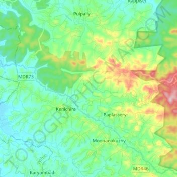
Nombre: Mapa topográfico Kenichira, altitud, relieve.
Altitud media: 788 m
Altitud mínima: 718 m
Altitud máxima: 989 m
Haz una donación
Otros mapas topográficos
Haga clic en un mapa para ver su topografía, su altitud y su relieve.
Sultan Bathery
India > Kerala > Sulthanbathery
Sulthan Bathery is located at 11°40′N 76°17′E / 11.67°N 76.28°E / 11.67; 76.28. It has an average elevation of 907 m (2,976 ft).
Altitud media: 876 m
Haz una donación
Haz una donación
Sultan Bathery
India > Kerala > Sulthanbathery
Sultan Bathery is located at 11°40′N 76°17′E / 11.67°N 76.28°E / 11.67; 76.28, on the Kozhikode–Kollegal National Highway (NH 766) 97 kilometers from Kozhikode. It is 114 km from Mysore and about 100 km from Ooty (Udagamandalam). It is also connected with Nilambur. It has an average…
Altitud media: 876 m
Haz una donación
Sultan Bathery
India > Kerala > Sulthanbathery
Sulthan Bathery is located at 11°40′N 76°17′E / 11.67°N 76.28°E / 11.67; 76.28. It has an average elevation of 907 m (2,976 ft).
Altitud media: 876 m