
Mapa topográfico Racovița
Mapa interactivo
Haga clic en el mapa para ver la altitud.
Acerca de este mapa
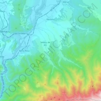
Nombre: Mapa topográfico Racovița, altitud, relieve.
Lugar: Racovița, Sibiu, Romania (45.58117 24.30931 45.70228 24.43388)
Altitud media: 674 m
Altitud mínima: 350 m
Altitud máxima: 2,119 m
Racovița Commune is situated at the base of Suru Peak (2,281 m or 7,484 ft) on the contact between the foothills of the Făgăraș Mountains and the low terrace of the floodplain, on the left bank of the river Olt, at an altitude of 385 meters. The commune borders to the north and northeast with the town Avrig; the border, which extends from the confluence of the small river Mârșa with the Olt to the Sorliței Peak, was established after the year 1200 and is marked with border signs called 'morminți'.
Otros mapas topográficos
Haga clic en un mapa para ver su topografía, su altitud y su relieve.
Lacul fără fund
Romania > Sibiu > Ocna Sibiului > Ocna Sibiului
Lacul fără fund, Ocna Sibiului, Sibiu, Romania
Altitud media: 414 m
Miercurea Sibiului
Romania > Sibiu > Miercurea Sibiului
Miercurea Sibiului, Sibiu, Romania
Altitud media: 432 m
Porumbacu
Romania > Sibiu > Porumbacu de Jos
Porumbacu, Porumbacu de Jos, Sibiu, 557192, Romania
Altitud media: 466 m