
Mapa topográfico Bukit Batok Town Park
Mapa interactivo
Haga clic en el mapa para ver la altitud.
Acerca de este mapa
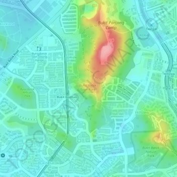
Nombre: Mapa topográfico Bukit Batok Town Park, altitud, relieve.
Altitud media: 41 m
Altitud mínima: 9 m
Altitud máxima: 135 m
Otros mapas topográficos
Haga clic en un mapa para ver su topografía, su altitud y su relieve.
Windsor Nature Park
Singapore > Central > Singapore
Windsor Nature Park, Bishan, Singapore, Central, Singapore
Altitud media: 32 m
Admiralty Park
Singapore > Northwest > Singapore
Admiralty Park, Woodlands, Singapore, Northwest, Singapore
Altitud media: 19 m
Sungei Tampines
Sungei Tampines, Tampines, Northeast, 520622, Singapore
Altitud media: 18 m
Jurong Hill Park
Jurong Hill Park, Boon Lay, Southwest, Singapore
Altitud media: 11 m
Hindhede Quarry
Hindhede Quarry, Bukit Panjang, Northwest, Singapore
Altitud media: 50 m
Pandan Reservoir
Singapore > Southwest > Jurong East
Pandan Reservoir, Jurong East, Southwest, Singapore
Altitud media: 6 m
Sungei Punggol
Sungei Punggol, Seletar, Central, 821325, Singapore
Altitud media: 8 m
Kent Ridge Park
Kent Ridge Park, Queenstown, Southwest, Singapore
Altitud media: 21 m
Jurong River
Singapore > Southwest > Jurong East
Jurong River, Jurong East, Southwest, Singapore
Altitud media: 7 m
Geylang River
Geylang River, Marine Parade, Southeast, Singapore
Altitud media: 9 m
Rochor River
Singapore > Central > Singapore
Rochor River, Kallang, Singapore, Central, 200815, Singapore
Altitud media: 10 m
Sungei Punggol
Sungei Punggol, Seletar, Central, 821325, Singapore
Altitud media: 8 m
Sungei Tongkang
Singapore > Central > Singapore
Sungei Tongkang, Serangoon North, Singapore, Central, Singapore
Altitud media: 18 m
Bishan-Ang Mo Kio Park
Bishan-Ang Mo Kio Park, Ang Mo Kio Neighbourhood Marker Sign, Sin Ming, Singapore, Central, 569983, Singapore
Altitud media: 24 m
Singapore River
Singapore > Central > Singapore
Singapore River, Singapore, Central, Singapore
Altitud media: 18 m
Gardens by the Bay
Gardens by the Bay, Marina South, Singapore, Central, Singapore
Altitud media: 5 m
Mount Faber Park
Mount Faber Park, Radin Mas, Harbourfront, Singapore, Central, Singapore
Altitud media: 20 m
East Coast Park (Zone H)
East Coast Park (Zone H), Tanah Merah, Southeast, Singapore
Altitud media: 5 m
Bukit Timah Hill
Bukit Timah Hill, Northwest, 589333, Singapore
Altitud media: 52 m
MacRitchie Reservoir
MacRitchie Reservoir, Upper Thomson Road, Bishan, Singapore, Central, 574331, Singapore
Altitud media: 28 m
Pearl's Hill City Park
Pearl's Hill City Park, Chinatown, Outram, Singapore, Central, Singapore
Altitud media: 18 m
Singapore Botanic Gardens
Singapore > Central > Singapore
Singapore Botanic Gardens, Tanglin, Singapore, Central, 259569, Singapore
Altitud media: 22 m
Clementi Woods
Clementi Woods, Clementi, Southwest, Singapore
Altitud media: 15 m
Kg. Sungai Belang
Kg. Sungai Belang, North-Eastern Islands, Southeast, Singapore
Altitud media: 13 m
Labrador Nature Reserve
Labrador Nature Reserve, Alexandra, Sentosa Cove, Southwest, Singapore
Altitud media: 11 m
Kg. Sanyongkong Parit
Kg. Sanyongkong Parit, North-Eastern Islands, Southeast, Singapore
Altitud media: 16 m
Rochor Canal
Singapore > Central > Singapore
Rochor Canal, Selegie, Rochor, Singapore, Central, 188505, Singapore
Altitud media: 15 m
Yunnan Park
Yunnan Park, Yunnan, Jurong West, Southwest, Singapore
Altitud media: 19 m
Kallang River
Kallang River, Singapore, Central, 570157, Singapore
Altitud media: 16 m
Ang Mo Kio Town Garden East
Ang Mo Kio Town Garden East, Ang Mo Kio Neighbourhood Marker Sign, Ang Mo Kio, Singapore, Central, Singapore
Altitud media: 22 m
Sembawang Park
Sembawang Park, Sembawang, Northwest, Singapore
Altitud media: 7 m
Pulau Serangoon (Coney Island)
Pulau Serangoon (Coney Island), Northeast, Singapore
Altitud media: 5 m
Tiong Bahru Park
Tiong Bahru Park, Radin Mas, Tiong Bahru, Singapore, Central, Singapore
Altitud media: 22 m
Zhenghua Nature Park
Zhenghua Nature Park, Bukit Panjang, Northwest, Singapore
Altitud media: 38 m
Fort Canning Park
Singapore > Central > Singapore
Fort Canning Park, Museum, Singapore, Central, Singapore
Altitud media: 19 m