
Mapa topográfico Malinalco
Mapa interactivo
Haga clic en el mapa para ver la altitud.
Acerca de este mapa
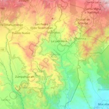
Nombre: Mapa topográfico Malinalco, altitud, relieve.
Lugar: Malinalco, State of Mexico, Mexico (18.75377 -99.55317 19.03329 -99.42443)
Altitud media: 1,871 m
Altitud mínima: 983 m
Altitud máxima: 3,364 m
As municipal seat, the town of Malinalco is the governing authority over 54 other named communities, which covers an area of 186.28km2. The municipality, which shares its name with the seat, has a population of 22,970 of which only 6,523 live in the town of Malinalco. It has an average elevation of 1750 meters above sea level and is bordered by the municipalities of Joquicingo, Ocuilan, Zumpahuacán, Tenancingo and the state of Morelos. Malinalco is wedged between the Trans-Mexican Volcanic Belt and the Sierra Norte of the state of Morelos, Elevations are higher in the north with the highest being the Cerro de la Loma at approximating 2700 meters above sea level. The major river here is the Chalma River, also called the Ocuilan River. Another river is the Colapa, which flows into the Chalma. There are also a number of fresh-water springs such as the San Miguel, Ateopa and Cuatzonco, most of which are the source of potable water for the communities of the municipality. The climate here is warm but not hot with rains mostly in the summer. The landscape is bright green in the summer and a golden color in the winter. Average temperatures vary between 20C in the higher elevations to 35C in the lower ones. The higher elevations mostly have mixed pine forests, with more tropical vegetation in the lowlands. Wildlife includes deer, various small mammals, a number of reptile species and birds.
Otros mapas topográficos
Haga clic en un mapa para ver su topografía, su altitud y su relieve.
Texcoco de Mora
Mexico > State of Mexico > Texcoco
Texcoco de Mora, Texcoco, State of Mexico, 56100, Mexico
Altitud media: 2,448 m
Ciudad Satélite
Mexico > State of Mexico > Naucalpan de Juárez
Ciudad Satélite, Naucalpan de Juárez, State of Mexico, 53100, Mexico
Altitud media: 2,299 m
Nevado de Toluca
Mexico > State of Mexico > Toluca
Nevado de Toluca, Toluca, State of Mexico, Mexico
Altitud media: 4,271 m
Barrio la Cascada (Barrio del Varal)
Mexico > State of Mexico > Temascaltepec
Barrio la Cascada (Barrio del Varal), Temascaltepec, State of Mexico, Mexico
Altitud media: 1,872 m
Ciudad López Mateos
Mexico > State of Mexico > Atizapán de Zaragoza
Ciudad López Mateos, Atizapán de Zaragoza, State of Mexico, 52940, Mexico
Altitud media: 2,426 m
Interlomas
Mexico > State of Mexico > Huixquilucan
Interlomas, Huixquilucan, State of Mexico, 52760, Mexico
Altitud media: 2,656 m
Teotihuacán
Teotihuacán, State of Mexico, 55845, Mexico
Altitud media: 2,346 m
Valle de Bravo
Mexico > State of Mexico > Valle de Bravo
Valle de Bravo, State of Mexico, 51200, Mexico
Altitud media: 1,914 m
Ojo de Agua
Mexico > State of Mexico > Tecámac
Ojo de Agua, Tecámac, State of Mexico, 55770, Mexico
Altitud media: 2,297 m
Rancho San Dimas
Mexico > State of Mexico > San Antonio la Isla
Rancho San Dimas, San Antonio la Isla, State of Mexico, 52220, Mexico
Altitud media: 2,585 m
Tlalnepantla de Baz
Tlalnepantla de Baz, State of Mexico, Mexico
Altitud media: 2,323 m
Cerro Prieto
Mexico > State of Mexico > Isidro Fabela
Cerro Prieto, Isidro Fabela, State of Mexico, 04830, Mexico
Altitud media: 3,415 m
Lerma de Villada
Mexico > State of Mexico > Lerma
Lerma de Villada, Lerma, State of Mexico, 52006, Mexico
Altitud media: 2,577 m
Endexhe
Mexico > State of Mexico > Lerma > Endexhe
Endexhe, Lerma, State of Mexico, 52050, Mexico
Altitud media: 2,740 m
Texcalyacac
Mexico > State of Mexico > Texcalyacac
Texcalyacac, State of Mexico, Mexico
Altitud media: 2,632 m
Cuautitlán
Mexico > State of Mexico > Cuautitlán
Cuautitlán, State of Mexico, Mexico
Altitud media: 2,258 m
Las Cruces
Las Cruces, Temascaltepec, State of Mexico, Mexico
Altitud media: 3,206 m
Monarch Butterfly Biosphere Reserve
Mexico > State of Mexico > Villa de Allende
Monarch Butterfly Biosphere Reserve, Villa de Allende, State of Mexico, Mexico
Altitud media: 2,461 m
Temascaltepec
Mexico > State of Mexico > Temascaltepec
Temascaltepec, State of Mexico, Mexico
Altitud media: 2,604 m
Jocotitlán
Mexico > State of Mexico > Jocotitlán
Jocotitlán, State of Mexico, Mexico
Altitud media: 2,674 m
Cacalomacan
Mexico > State of Mexico > Toluca > Cacalomacan
Cacalomacan, Toluca, State of Mexico, 50265, Mexico
Altitud media: 2,790 m
Tlalnepantla
Mexico > State of Mexico > Tlalnepantla de Baz
Tlalnepantla, Tlalnepantla de Baz, State of Mexico, 54000, Mexico
Altitud media: 2,358 m
Predio de los Albertocos
Mexico > State of Mexico > Temamatla > Temamatla > Predio de los Albertocos
Predio de los Albertocos, Temamatla, State of Mexico, Mexico
Altitud media: 2,313 m
Santa María Tulpetlac
Mexico > State of Mexico > Ecatepec de Morelos > Santa María Tulpetlac
Santa María Tulpetlac, Ecatepec de Morelos, State of Mexico, 55400, Mexico
Altitud media: 2,280 m
San Franciso de Asís
San Franciso de Asís, State of Mexico, Mexico
Altitud media: 890 m
La Marquesa
Mexico > State of Mexico > La Marquesa
La Marquesa, Ocoyoacac, State of Mexico, 05750, Mexico
Altitud media: 3,138 m
Huixquilucan
Mexico > State of Mexico > Huixquilucan
Huixquilucan, State of Mexico, Mexico
Altitud media: 2,921 m
Santa Catarina
Mexico > State of Mexico > Lerma
Santa Catarina, Lerma, State of Mexico, 52055, Mexico
Altitud media: 2,602 m
Zinacantepec
Mexico > State of Mexico > Zinacantepec
Zinacantepec, State of Mexico, Mexico
Altitud media: 3,103 m
Barrio Paraiso
Mexico > State of Mexico > Huixquilucan > Barrio Paraiso
Barrio Paraiso, Huixquilucan, State of Mexico, 52773, Mexico
Altitud media: 2,679 m
Trojes
Mexico > State of Mexico > Luvianos > Trojes
Trojes, Luvianos, State of Mexico, 51440, Mexico
Altitud media: 1,143 m
Teoloyucan
Mexico > State of Mexico > Teoloyucan
Teoloyucan, State of Mexico, Mexico
Altitud media: 2,253 m
Chapultepec
Mexico > State of Mexico > Chapultepec
Chapultepec, State of Mexico, Mexico
Altitud media: 2,587 m
Tequixquiac
Mexico > State of Mexico > Tequixquiac
Tequixquiac, State of Mexico, Mexico
Altitud media: 2,296 m
Naucalpan
Mexico > State of Mexico > Naucalpan de Juárez
Naucalpan, Naucalpan de Juárez, State of Mexico, 53370, Mexico
Altitud media: 2,459 m
Nevado de Toluca
Nevado de Toluca, Tenango del Valle, State of Mexico, Mexico
Altitud media: 4,037 m
Popocatépetl
Mexico > State of Mexico > Atlautla
Popocatépetl, Atlautla, State of Mexico, Mexico
Altitud media: 4,810 m