
Mapa topográfico Alamogordo
Mapa interactivo
Haga clic en el mapa para ver la altitud.
Acerca de este mapa
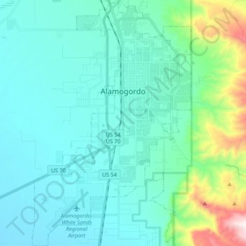
Nombre: Mapa topográfico Alamogordo, altitud, relieve.
Lugar: Alamogordo, Otero County, New Mexico, United States (32.81874 -106.01686 32.94756 -105.91772)
Altitud media: 1,515 m
Altitud mínima: 1,248 m
Altitud máxima: 2,467 m
As of 2010, Alamogordo had a total area of 19.3 square miles (50.0 km2), all of it land. The city is located at an elevation of 4,336 feet (1,322 m) on the western flank of the Sacramento Mountains and on the eastern edge of the Tularosa Basin. It lies within the Rio Grande rift and in the northernmost part of the Chihuahuan Desert.:36 Tectonic activity is low in the Tularosa Basin. Plants native to the area are typical of the southern New Mexico foothills and include creosote bush, mesquite, saltbush, cottonwood, desert willow, and many species of cactus and yucca.
Otros mapas topográficos
Haga clic en un mapa para ver su topografía, su altitud y su relieve.
Cloudcroft
United States > New Mexico > Otero County
Cloudcroft, Otero County, New Mexico, United States
Altitud media: 2,643 m
Alamorosa
United States > New Mexico > Otero County
Alamorosa, Otero County, New Mexico, 88337, United States
Altitud media: 1,365 m
La Luz
United States > New Mexico > Otero County
La Luz, Otero County, New Mexico, 88337, United States
Altitud media: 1,452 m
Orogrande
United States > New Mexico > Otero County
Orogrande, Otero County, New Mexico, 88342, United States
Altitud media: 1,285 m
Weed
United States > New Mexico > Otero County
Weed, Otero County, New Mexico, 88354, United States
Altitud media: 2,212 m
Timberon
United States > New Mexico > Otero County
Timberon, Otero County, New Mexico, 88350, United States
Altitud media: 2,181 m
Apache
United States > New Mexico > Otero County
Apache, Otero County, New Mexico, United States
Altitud media: 1,957 m
Cloudcroft
United States > New Mexico > Otero County > Cloudcroft
Cloudcroft, Otero County, New Mexico, 88317, United States
Altitud media: 2,636 m
White Sands National Park
United States > New Mexico > Otero County
White Sands National Park, Otero County, New Mexico, United States
Altitud media: 1,214 m
Alamogordo
United States > New Mexico > Otero County
Alamogordo, Otero County, New Mexico, 88310, United States
Altitud media: 1,644 m
La Luz
United States > New Mexico > Otero County
La Luz, Otero County, New Mexico, 88337, United States
Altitud media: 1,493 m
High Rolls
United States > New Mexico > Otero County
High Rolls, Otero County, New Mexico, 88325, United States
Altitud media: 2,036 m
Mayhill
United States > New Mexico > Otero County
Mayhill, Otero County, New Mexico, United States
Altitud media: 2,104 m
Sacramento
United States > New Mexico > Otero County
Sacramento, Otero County, New Mexico, 88347, United States
Altitud media: 2,320 m