
Mapa topográfico Jammu and Kashmir
Mapa interactivo
Haga clic en el mapa para ver la altitud.
Acerca de este mapa
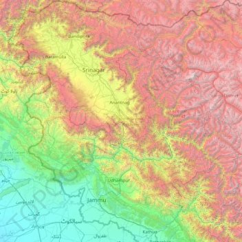
Nombre: Mapa topográfico Jammu and Kashmir, altitud, relieve.
Lugar: Jammu and Kashmir, India (32.27636 73.75003 34.78714 76.78032)
Altitud media: 2,430 m
Altitud mínima: 208 m
Altitud máxima: 7,015 m
Jammu and Kashmir is home to several valleys such as the Kashmir Valley, Tawi Valley, Chenab Valley, Poonch Valley, Sind Valley, and Lidder Valley. The Kashmir valley is 100 km (62 mi) wide and 15,520.3 km2 (5,992.4 sq mi) in area. The Himalayas divide the Kashmir valley from the Tibetan plateau while the Pir Panjal range, which encloses the valley from the west and the south, separates it from the Punjab Plain of the Indo-Gangetic Plain. Along the northeastern flank of the Valley runs the main range of the Himalayas. This valley has an average height of 1,850 metres (6,070 ft) above sea-level, but the surrounding Pir Panjal range has an average elevation of 10,000 feet (3,000 m). The Jhelum River is the major Himalayan river which flows through the Kashmir valley. The southern Jammu region is mostly mountainous, with the Shivaliks, the middle and the great Himalayas running parallel to each other in a southeast-northwest direction. A narrow southwestern strip constitutes fertile plains. The Chenab, Tawi and Ravi are important rivers flowing through the Jammu region.
Otros mapas topográficos
Haga clic en un mapa para ver su topografía, su altitud y su relieve.
Bengaluru
India > Karnataka > Bangalore North
Bengaluru, Bangalore North, Bengaluru Urban District, Karnataka, India
Altitud media: 881 m
3d
India > Rajasthan > Ganganagar Tehsil > 1 LNP
3d, 1 LNP, Ganganagar Tehsil, Sri Ganganagar District, Rajasthan, India
Altitud media: 178 m
Srinagar
India > Jammu and Kashmir > Srinagar (South)
Srinagar, Srinagar (South), Srinagar District, Jammu and Kashmir, 190001, India
Altitud media: 1,805 m
Mysuru
India > Karnataka > Mysuru taluk
Mysuru, Mysuru taluk, Mysuru District, Karnataka, 570001, India
Altitud media: 727 m
Pune
India > Maharashtra > Pune City > Pune
Pune, Pune City, Pune District, Maharashtra, 411001, India
Altitud media: 641 m
Prayagraj
India > Uttar Pradesh > Prayagraj
Prayagraj, Prayagraj District, Uttar Pradesh, 211001, India
Altitud media: 91 m
Jagdevpur mandal
Jagdevpur mandal, Siddipet District, Telangana, India
Altitud media: 537 m
Suryanelli
India > Kerala > Udumbanchola
Suryanelli, Udumbanchola, Idukki District, Kerala, India
Altitud media: 1,553 m
Bachupally mandal
Bachupally mandal, Medchal–Malkajgiri District, Telangana, 500090, India
Altitud media: 593 m
Murbad
India > Maharashtra > Murbad Taluka > Murbad
Murbad, Murbad Taluka, Thane District, Maharashtra, India
Altitud media: 91 m
Kodangal
India > Telangana > Kodangal mandal
Kodangal, Kodangal mandal, Vikarabad District, Telangana, 509338, India
Altitud media: 553 m
Whitefield
India > Karnataka > Bangalore East > Bengaluru
Whitefield, Bengaluru, Bangalore East, Bengaluru Urban District, Karnataka, 560066, India
Altitud media: 875 m
Gurgaon
India > Haryana > Gurugram District
Gurgaon, Gurugram District, Haryana, India
Altitud media: 237 m
Vijayawada
India > Andhra Pradesh > Vijayawada (Urban)
Vijayawada, Vijayawada (Urban), NTR District, Andhra Pradesh, 520001, India
Altitud media: 36 m
Jaipur
India > Rajasthan > Jaipur Tehsil
Jaipur, Jaipur Municipal Corporation, Jaipur Tehsil, Jaipur District, Rajasthan, 302001, India
Altitud media: 408 m
Sultanpur Lodhi
India > Punjab > Sultanpur Lodhi Tahsil
Sultanpur Lodhi, Sultanpur Lodhi Tahsil, Kapurthala District, Punjab, 144626, India
Altitud media: 214 m
Banjar
India > Himachal Pradesh > Bhuntar
Banjar, Bhuntar, Kullu District, Himachal Pradesh, 175125, India
Altitud media: 1,271 m