
Haz una donación
Mapa topográfico Yamuna
Haga clic en el mapa para ver la altitud.
Haz una donación
Yamuna
The source of Yamuna lies in the Yamunotri Glacier at an elevation of 6,387 metres (20,955 ft), on the southwestern slopes of Banderpooch peaks, which lie in the Mussoorie range of the Lower Himalayas, north of Haridwar in Uttarkashi district, Uttarakhand. Yamunotri temple, a shrine dedicated to the goddess Yamuna, is one of the holiest shrines in Hinduism, and part of the Chota Char Dham Yatra circuit. Also standing close to the temple, on its 13-kilometre (8 mi) trek route that follows the right bank of the river, lies Markendeya Tirtha, where the sage Markandeya wrote the Markandeya Purana.
Haz una donación
Acerca de este mapa
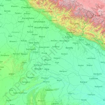
Nombre: Mapa topográfico Yamuna, altitud, relieve.
Lugar: Yamuna, India (25.25727 77.09509 31.02743 81.89233)
Altitud media: 707 m
Altitud mínima: 75 m
Altitud máxima: 7,431 m
Haz una donación
Otros mapas topográficos
Haga clic en un mapa para ver su topografía, su altitud y su relieve.
Kangchenjunga
India > Sikkim > Chungthang
Kangchenjunga Main is the highest elevation of the Brahmaputra River basin, which forms part of the southeast Asian monsoon regime and is among the globally largest river basins. Kangchenjunga is one of six peaks above 8,000 m (26,000 ft) located in the basin of the Kosi River, which is among the largest…
Altitud media: 7,725 m
Madikeri
India > Karnataka > Madikeri taluku
Madikeri features a tropical highland climate as it has an elevation of 1,170 m (3,840 ft). Madikeri is located at 12°25′N 75°44′E / 12.42°N 75.73°E / 12.42; 75.73. Madikeri lies in the Western Ghats and is a popular hill station. Nearest major cities are Hassan (110 kilometres (68 mi)) to the…
Altitud media: 1,054 m
Mussoorie
India > Uttarakhand > Dehradun
Mussoorie is at an average altitude of 2,005 metres (6,578 ft). To the northeast are the Himalayan snow ranges, and to the south, the Doon Valley and Shiwalik ranges. The second highest point is the original Lal Tibba in Landour, with a height of over 2,275 m (7,464 ft). Mussoorie is popularly known as The…
Altitud media: 1,594 m
Haz una donación
Dehradun
India > Uttarakhand > Dehradun
The city of Dehradun mainly lies in Doon Valley and is at a varying height from 410 m (1,350 ft) in Clement Town to above 700 m (2,300 ft) at Malsi which is 15 km (9.3 mi) from the city. However, the average elevation is 450 m (1,480 ft) above sea level. Malsi is the starting point of Lesser Himalayan Range…
Altitud media: 904 m
Pasighat
India > Arunachal Pradesh > Pasighat HQ
Pasighat is located at 28°04′N 95°20′E / 28.07°N 95.33°E / 28.07; 95.33. It has an average elevation of 153 metres or 502 feet. Pasighat has a typical lowland Northeast India humid subtropical climate (Köppen Cwa) a little too cool to qualify as a tropical monsoon climate (Am).
Altitud media: 179 m
Haz una donación
Habra
India > West Bengal > Habra - I
Habra is located at 22°50′N 88°38′E / 22.83°N 88.63°E / 22.83; 88.63. It has an average elevation of 13 metres (42 feet).
Altitud media: 7 m
Haz una donación
Rudraprayag
India > Uttarakhand > Rudraprayag
Rudraprayag district is located at 30°17′N 78°59′E / 30.28°N 78.98°E / 30.28; 78.98. It has an average elevation of 895 metres (2,936 feet).
Altitud media: 1,140 m
Haz una donación
Bengaluru
India > Karnataka > Bangalore North
Bangalore (/ˈbæŋɡəlɔːr, ˌbæŋɡəˈlɔːr/ BANG-gə-lor, -LOR), officially Bengaluru (Kannada: [ˈbeŋgɐɭuːɾu] ; ISO: Beṁgaḷūru), is the capital and largest city of the southern Indian state of Karnataka. It has a population of more than 8 million and a metropolitan population of around 15…
Altitud media: 879 m
Mysuru
India > Karnataka > Mysuru taluk
Mysore is situated at the foothills of the Chamundi Hills. At an altitude of 770 m (2,530 ft) above mean sea level, the city of Mysore is geographically located at 12° 18′ 26″ north latitude and 76° 38′ 59″ east longitude. It is about 140 km (87.0 mi) southwest of the state's capital, Bangalore, and…
Altitud media: 727 m
Jammu
India > Jammu and Kashmir > Jammu
Jammu is located at 32°44′N 74°52′E / 32.73°N 74.87°E / 32.73; 74.87. It has an average elevation of 300 m (980 ft). Jammu city is situated on a series of uneven ridges of low heights in the Shivalik hills. It is surrounded by the Shivalik range to the north, east, and southeast while the…
Altitud media: 367 m
Srinagar
India > Jammu and Kashmir > Srinagar (South)
Under the Köppen climate classification, Srinagar has a four-season humid subtropical climate (Cfa) with hot summers and cool winters. The valley is surrounded by the Himalayas on all sides. Due to influence from Himalayan rain shadow and western disturbances, Srinagar has year-round precipitation; the spring…
Altitud media: 1,805 m
Haz una donación
Haz una donación
Purulia
India > West Bengal > Purulia - II
Purulia is located at 23°20′N 86°22′E / 23.33°N 86.37°E / 23.33; 86.37. It has an average elevation of 228 metres (748 feet).
Altitud media: 241 m
Haz una donación
Haz una donación
Lucknow
India > Uttar Pradesh > Lucknow
Lucknow stands at an elevation of approximately 123 metres (404 ft) above sea level. The city had an area of 402 km2 (155 square miles) until December 2019, when 88 villages were added to the municipal limits and the area increased to 631 km2 (244 square miles). Bounded on the east by Barabanki, on the west by…
Altitud media: 120 m
Hoshiarpur
India > Punjab > Hoshiarpur Tahsil
Hoshiarpur has an average elevation of 296 metres (971 ft). Hoshiarpur district is located in the north-east part of the Indian state of Punjab. It falls in the Jalandhar Revenue Division and is situated in the Bist Doab portion of the Doaba region. Hoshiarpur shares a boundary with Kangra district, and Una…
Altitud media: 327 m
Haz una donación
Udhagamandalam
India > Tamil Nadu > Udhagamandalam
Ooty is located in the Nilgiri hills, which form a part of the Western Ghats in the Nilgiri Biosphere Reserve. It is separated from the neighboring state of Karnataka by the Moyar river in the north and from the Anaimalai and Palani hills in the south by the Palghat Gap. It is situated at an altitude of 2,240…
Altitud media: 2,234 m
Haz una donación
Visakhapatnam
India > Andhra Pradesh > Visakhapatnam (Urban)
The city is situated between the Eastern Ghats and the Bay of Bengal. The city coordinates lies between 17.7041 N and 83.2977 E. The city's area is 682 km2. The average elevation is 45 metres. Visakhpatnam is situated in Coastal Andhra Region.
Altitud media: 41 m
Vagamon
Vagamon, due to its elevation and climate, has a unique ecosystem, leading to the emergence of rich natural vegetation, plant species, shola forests etc. From the early 20th century plantation grew crops like tea and coffee. Vagamon hills are home to less explored flora and fauna. A diversity study conducted…
Altitud media: 866 m
Haz una donación
Baran
India > Rajasthan > Baran Tehsil
Baran is located at 25°06′N 76°31′E / 25.1°N 76.52°E / 25.1; 76.52. It has an average elevation of 262 metres (859 ft). It is surrounded by three Rivers Kalisindh, Parvati and Parban. The city is situated on the border of Rajasthan and Madhya Pradesh.
Altitud media: 264 m
Haz una donación
Haz una donación
Haz una donación
Haz una donación
Haz una donación
Haz una donación
Bagalkote
Bagalkote, is a city in the state of Karnataka, India, which is also the headquarters of Bagalkote district. It is situated on branch of River Ghataprabha about 481 km (299 mi) northwest of state capital Bangalore, 410 km (255 mi) southwest of Hyderabad, and about 570 km (354 mi) southeast of Mumbai. The…
Altitud media: 556 m
Haz una donación
Harihara
India > Karnataka > Harihara taluku > Harihara
Harihara is located at 14°31′N 75°48′E / 14.52°N 75.8°E / 14.52; 75.8. It has an average elevation of 540 metres (1771 feet).
Altitud media: 545 m
Haz una donación
Haz una donación
Haz una donación